拖拉机牵引特性曲线tractive characteristic curveof tractor
反映拖拉机在不同土壤条件下水平地段稳定工作时,其牵引性和燃料经济性指标随水平负载而变化的规律曲线。该曲线把拖拉机的滑转率、实际速度、牵引功率、小时耗油量和耗油率随牵引力而变化的关系综合在一起,较全面地反映出拖拉机各种性能指标间的联系,可用以分析比较、评价拖拉机牵引机组的性能,为选配农机具提供可靠的依据。
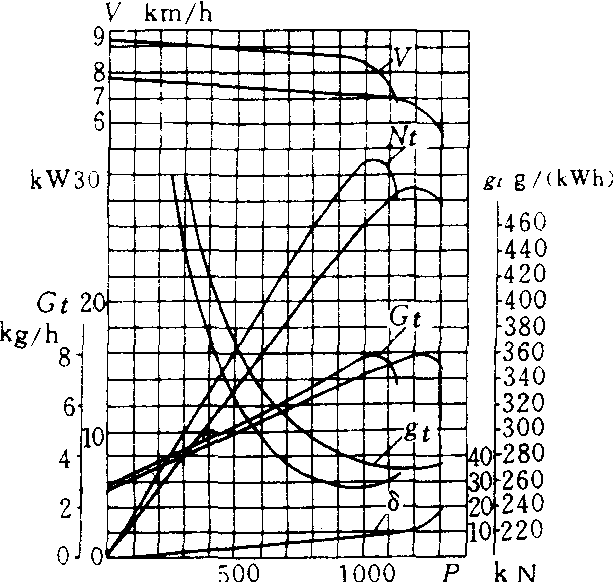
拖拉机牵引特性曲线
V.拖拉机前进速度 Nt. 拖拉机牵引功率 Gt. 发动机小时耗油量 P.拖拉机牵引力 δ. 拖拉机滑转率 gt. 发动机耗油率
- cassia
- Cassini′s Division
- Cassini,Gioyanni Domenico
- Cassino
- Cassiodorus, Flavius Magnus Aurelius
- Cassiopeia
- Cassirer,Ernst
- cassiterite
- Cassites
- Cassius Longinus,Gaius
- Cassius Longinus,Quintus
- Cassivellaunus
- Casson,Sir Hugh Maxwell
- cassowary
- Cass,Lewis
- Castagno,Andrea del
- castanets
- Castel Gandolfo
- Castellamare di Stabia
- Castellon de la Plana
- Castelo Branco,Camilo
- Castelo Branco,Humberto
- caste system
- Castiglione,Baldassare
- Castiglione, Giovanni Benedetto