昆虫病原病毒insect pathogenic viruses
以昆虫为寄主并使昆虫致病的一类病毒。病毒只含有一种类型的DNA或RNA,无细胞结构,只能在活的寄主细胞内复制增殖。昆虫病毒分为包涵体病毒和无包涵体病毒两类。包涵体病毒大都能在寄主细胞内形成蛋白质结晶状的包涵体,包括核型多角体病毒(NPV)、颗粒体病毒(GV)、质型多角体病 毒(CPV)和昆虫痘病毒(EPV): 前3类病毒所引起的疾病占已知昆虫病毒的一半以上,是研究和开发病毒资源的重点。另一类不形成包涵体,统称无包涵体病毒,其中较重要的有虹彩病毒(IV)和浓核病毒 (DNV)。在已发现的种类中最为庞杂的是小RNA病毒,体微小、特性各异、彼此间很少有血清学关系。
分类 迄今已记载昆虫和蜱螨类的病毒1690多种,中国已知200多种。根据国际病毒分类委员会 (ICTV)先后5次修改通过的分类方案,至今昆虫病毒分属于杆状病毒科(Baculoviridae)、昆虫痘病毒科 (Ento-mopoxviridae)、虹彩病毒科(Iridoviridae)、细小病毒科(Parvoviridae)、呼肠孤病毒科 (Reoviridae)、弹状病毒科(Rhabdoviridae)、微核糖核酸病毒 科(Picornaviridae)、野田村病毒科(Nodaviridae)、双片段双股RNA病毒科(Birnaviridae)及松天蚕蛾β病毒类群(Nudaurelia β-virus group)等。此外尚有许多昆虫病毒,因理化性质不明而未纳入分类系统。这些病毒大部分是小RNA病毒,包括蜜蜂麻痺症病毒和果蝇σ病毒 (Drosophila σ-virus) 等。目前的病毒分类(包括昆虫病毒的分类),只是现有的资料和观点,尚不完善。
特性 生物学特性包括形态结构、寄主范围、致病性、罹病寄主的症状、病毒的侵入和复制过程以及传递方式等。
核型多角体病毒 研究得最早和最为详细的一 类病毒。因包涵体呈多角体(在光学显微镜下极易看到)和只在寄主细胞核内复制而得名。多角体通过幼虫食入,肠道消化液的消化,释放出有感染性的病毒粒子;病毒粒子穿过肠壁细胞和微绒毛膜,侵染敏感的组织、细胞。游离的病毒粒子随机包埋在结晶蛋白之中,形成一个个含有杆状病毒粒子的多角体(图1a)。病毒粒子的包埋类型有:单粒包埋(SEV),病毒中只含一个病毒粒子(图1c); 多粒包埋(MEV),两个以上粒子成束包埋(图1b)。包涵体的形成由病毒本身决定。核型多角体DNA分子呈双链结构,病毒粒子结构复杂,约含10~25个多肽。以鳞翅目许多昆虫为寄主的多角体病毒主要感染血细胞、脂肪体细胞(图1d)、气管底膜细胞、体壁细胞和肠道细胞等; 以膜翅目叶蜂类为寄拦时,则只局限于感染幼虫中肠的细胞。患核型多角体病毒病的幼虫食欲减退、反应迟钝、体色灰白、后期体壁肿胀、轻触即破,从感病到死亡的时间取决于寄主、食入多角体数量、虫龄及环境温度等因素,一般需4天以上。多角体病毒的寄主仅限于昆虫,以鳞翅目为主,还有膜翅目、双翅目、鞘翅目、脉翅目、毛翅目的一些种类。其致病力强并有后效。对人畜安全,作为微生物杀虫剂比较理想,可进一步开发利用,在国际上已有多种登记生产。中国目前应用于大田防治的有油桐尺蠖NPV、棉铃虫NPV、茶毛虫NPV等,均获良好效果。由于NPV多角体蛋白基因启动子表达能力强,病毒对外源DNA容量大,因此它又是当今基因工程中的良好载体。
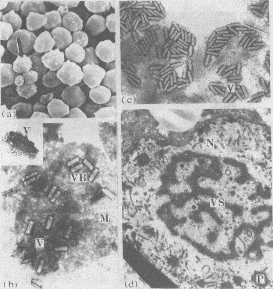
图1 多角体病毒的包埋类型及其在细胞核内的增殖
(a)李枯叶蛾NPV多角体扫描电镜图像,箭头示多角体表面的病毒粒子;(b)李枯叶蛾NPV经碱解后,多角体膜内包埋着大量成束的病毒粒子(VB),示病毒粒子为多粒包埋(MEV);(c)烟膏虫多角体内单个病毒粒子,示单粒包埋(SEV);(d)烟膏虫幼虫感染多角体病毒48小时后的脂肪体细胞,VS为病毒发生基质,P为包埋中的多角体
颗粒体病毒 包涵体是一个椭圓形或卵圓形的小颗粒。光学显微镜下几乎接近于分辨率的极限。通常一个颗粒体只含一个杆状病毒粒子,偶然有2个以上的。有些畸形颗粒体比正常者长几倍(左图箭头所指)。颗粒体病毒形态发生较为特殊,有的结晶状蛋白沿着核衣壳从一端往前堆积,也有从核衣壳两端延伸堆积,逐渐形成一个完整的颗粒体。属于B亚组的颗粒体病毒可侵染脂肪体细胞,体壁细胞、气管底膜细胞和中肠肠壁细胞等;可在核内或细胞质内复制增殖。感染途径与NPV同,经口和卵传染,易潜伏感染。罹病早期幼虫外观病征不明显,后期色泽变淡,腹面呈乳白色,体节肿胀,虫尸易液化,体液混浊含有大量的颗粒体病毒。发病过程较长,一般需5~25天死亡。寄主范围特异性较高,很少有不同科、属间相互感染的现象。其遗传物质是双螺旋结构的DNA,分子量较大。主要侵染鳞翅目的多种昆虫。是一种有应用前途的微生物杀虫剂; 中国研究的菜青虫GV等已获较好防治效果,国外对CV的研究和应用也有成功之例。
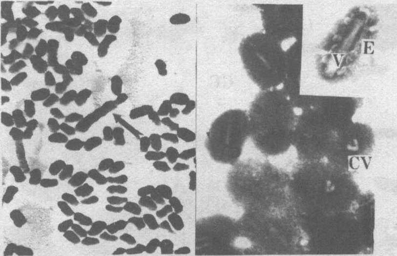
图2 颗粒体病毒
左图为分月扇舟蛾颗粒体病毒; 右图为碱处理后的分月扇舟蛾颗粒体病毒粒子。E:病毒粒子膜; V:病毒粒子;CV: 弯形粒子
质型多角体病毒 包涵体也是多角体,为不规则的多边形,在不同寄主中其形态、大小差别很大。每个多角体随机包埋着成千个呈正20面体球形的病毒粒子,大小约50~70纳米。通常只感染幼虫中肠的柱状和杯状细胞,在细胞质内复制增殖(图3、4)。黄地老虎感病中肠的围食膜内也有CPV病毒复制现象(为中国首次发现)。CPV的遗传物质是RNA,具有双螺旋结构。罹病幼虫显得头大体小,后期中肠烂, 排出的粪便含有大量的多角体。 经口和卵传染,在人工饲养的昆虫种群中易发生CPV病。一般发病迟缓,病程较长,但认为CPV是一种有效的杀虫剂。如赤毛虫CPV商品制剂已在日本注册。中国利用赤毛虫CPV和马尾松毛虫CPV在林区防治害虫已获明显效果。CPV主要寄生鳞翅目昆虫,有时也感染膜翅目和双翅目的一些种类。由于CPV病毒的理化性质和其他动、植物的呼肠孤病毒较为接近,需进一步证明在应用中其对环境有否不良影响。
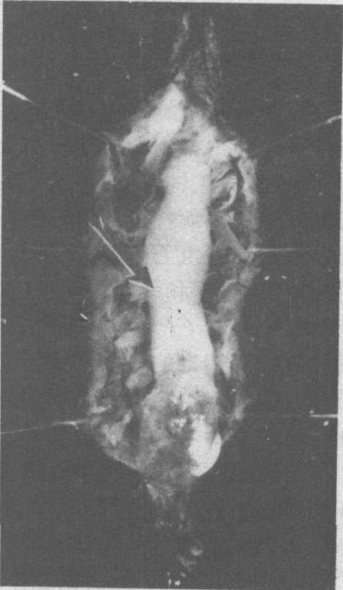
图3 感染黄地老虎CPV的櫂病幼虫
箭头示肿大变白的中肠
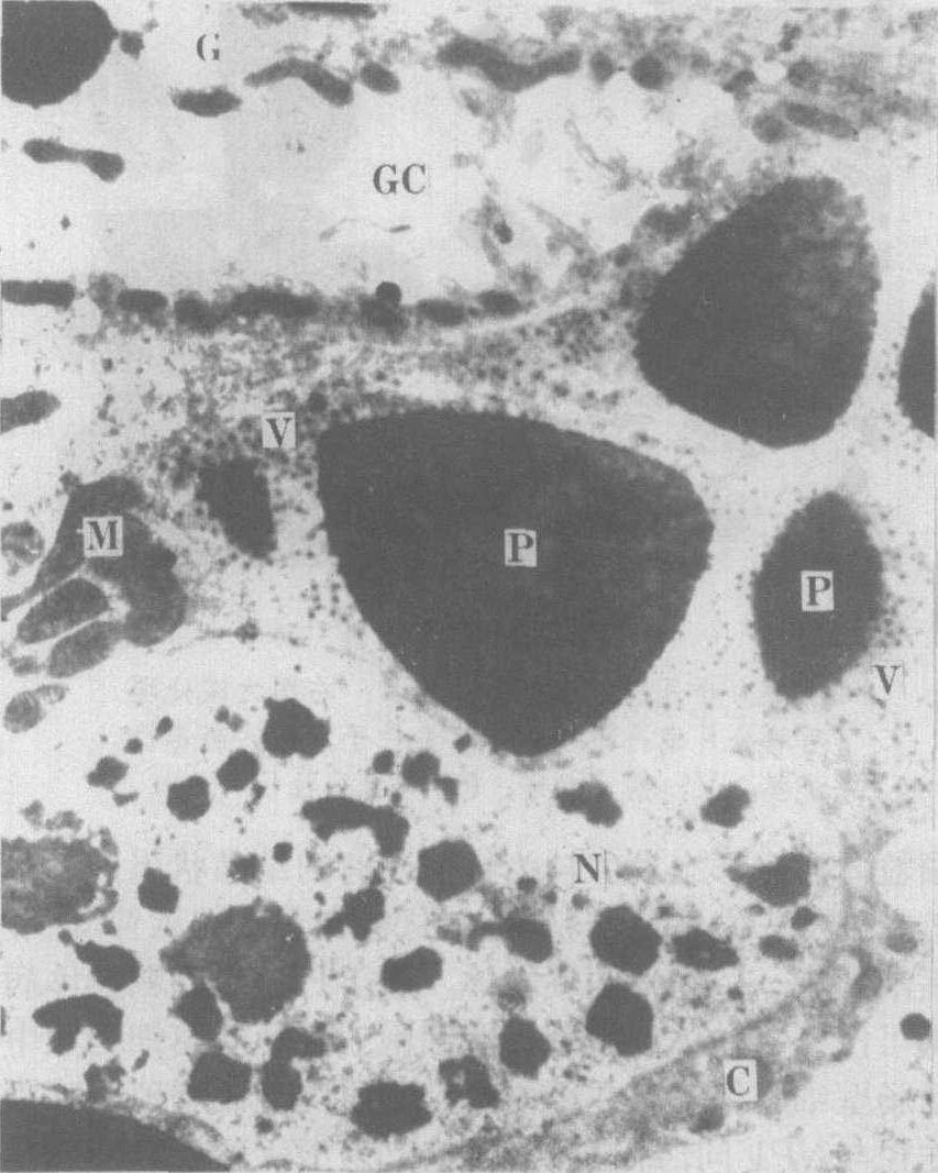
图4 黄地老虎感染7日后,中肠柱状细胞(C)和杯状细胞(G)的超薄切片。
GC:杯细胞腔; M:线粒体;P:包埋中的多角体;V:病毒粒子
昆虫痘病毒 在昆虫受感染的细胞中产生球状体和纺锤体两种包涵体(图5),后者无病毒粒子。包涵体在光学显微镜下易见。病毒粒子呈砖形或椭圆形,粒子随机包埋在结晶状蛋白包涵体中。核酸为双链DNA。寄生鞘翅目、鳞翅目、双翅目、直翅目和膜翅目昆虫;经口和血腔接种传递,主要在血细胞和脂肪体细胞质内增殖,与脊椎动物痘病毒无血清学关系。罹病幼虫发病缓慢,初期症状不明显。病虫行动迟缓、后期体色乳白,几个月后死亡。
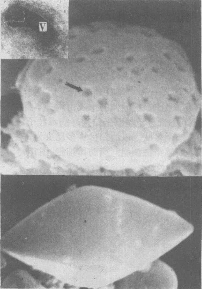
图5 昆虫的痘病毒
上图为苹毛丽金龟痘病毒的球状体,表面有许多凹陷(箭头),可能是病毒粒子脱落后留下的。V:成熟的毒粒子;下图为苹毛丽金龟痘病毒的纺锤体
虹彩病毒 无包涵体病毒。是昆虫病毒中的一大类群,最初从英国的欧洲大蚊中发现,寄生双翅目、鳞翅目和鞘翅目昆虫。最大的特点是提纯的病毒或在寄主组织中的病毒均对光反射产生虹彩。经口和血腔接种传递,侵染脂肪体和其他多种组织细胞而致昆虫死亡。这类病毒在中国尚未见报道。
浓核病毒 无包涵体病毒。寄生鳞翅目、双翅目、鞘翅目、膜翅目昆虫; 代表种之一是大蜡螟浓核病毒。传染途径同于虹彩病毒。感染力强,几乎侵染寄主昆虫个部虫态和所有组织; 在细胞核内增殖。
- Izvolsky,Aleksandr Petrovich
- J0ao Pessoa
- Jabalpur
- jabiru
- jaborandi
- jacamar
- jacana
- jacaranda
- jack
- jackal
- jackdaw
- Jacklin,Tony
- Jackrabbit
- Jack Russell terrier
- Jackson
- Jackson
- Jackson Hole
- Jacksonville
- Jackson,Andrew
- Jackson,Glenda
- Jackson,Helen Fiske Hunt
- Jackson,Mahalia
- Jackson,Robeit Houghwout
- Jackson,Shirley
- Jackson,Thomas Jonathan