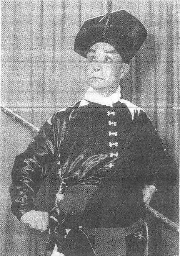
请输入您要查询的百科知识:


词条 Cushing, Maine
释义

  1. History

  2. Geography

  3. Demographics

     2010 census  2000 census 

  4. Notable people

  5. References

  6. External links

{{Infobox settlement
|official_name = Cushing, Maine
|settlement_type = Town
|nickname =
|motto =
|image_skyline = ME18 Olson House, Maine.jpg
|imagesize =
|image_caption = Olson House, 1995
|image_flag =
|image_seal =
|image_map = Knox County Maine incorporated and unincorporated areas Cushing highlighted.svg
|mapsize = 260px
|map_caption = Location in Knox County and the state of Maine
|subdivision_type = Country
|subdivision_name = United States
|subdivision_type1 = State
|subdivision_name1 = Maine
|subdivision_type2 = County
|subdivision_name2 = Knox
|parts_type = Villages
|parts = Cushing
North Cushing
South Cushing
|government_footnotes =
|government_type =
|leader_title =
|leader_name =
|leader_title1 =
|leader_name1 =
|established_title = Incorporated
|established_date = 1789
|unit_pref = Imperial
|area_footnotes = [1]
|area_magnitude =
|area_total_km2 = 67.47
|area_land_km2 = 49.83
|area_water_km2 = 17.64
|area_total_sq_mi = 26.05
|area_land_sq_mi = 19.24
|area_water_sq_mi = 6.81
|population_as_of = 2010
|population_est = 1522
|pop_est_as_of = 2012[1]
|population_footnotes = [3]
|population_total = 1534
|population_density_km2 = 30.8
|population_density_sq_mi = 79.7
|timezone = Eastern (EST)
|utc_offset = -5
|timezone_DST = EDT
|utc_offset_DST = -4
|elevation_footnotes =
|elevation_m = 26
|elevation_ft = 85
|coordinates = {{coord|43|59|36|N|69|16|5|W|region:US-ME|display=inline}}
|postal_code_type = ZIP code
|postal_code = 04563
|area_code = 207
|blank_name = FIPS code
|blank_info = 23-15780
|blank1_name = GNIS feature ID
|blank1_info = 0582428
|website =
|footnotes =
}}

Cushing is a town in Knox County, Maine, United States. The population was 1,534 at the 2010 census. A favorite of artists for its unspoiled natural setting, Cushing includes the villages of North Cushing, Cushing, South Cushing, and Pleasant Point.

History

Part of the Waldo Patent, it was called the Lower Plantation of St. Georges, once extending across both sides of the St. George River. It was first permanently settled in 1733 with Scots and Irish immigrants recruited from Ireland by Brigadier-General Samuel Waldo, who offered {{convert|100|acre|km2}} for each household. Attacks during the French and Indian Wars, however, deterred habitation. A stone blockhouse known as Burton's Fort was built in 1753 by its commander, Captain Benjamin Burton. Hostilities finally ceased in 1759 with the Fall of Quebec.[2] On January 28, 1789, the town was incorporated and named for Thomas Cushing,[3] statesman and lieutenant governor of Massachusetts. On February 7, 1803, the town of St. George was set off and incorporated.[4]

The Olson House was depicted in Andrew Wyeth's 1948 painting, Christina's World, which in turn was used as Dahlia Gillespie's house in the horror video game series Silent Hill, and inspired the farmer's house in the 1978 film Days of Heaven. The building is now operated by the Farnsworth Art Museum of Rockland.[5]

Geography

According to the United States Census Bureau, the town has a total area of {{convert|26.05|sqmi|sqkm|2}}, of which, {{convert|19.24|sqmi|sqkm|2}} of it is land and {{convert|6.81|sqmi|sqkm|2}} is water.[6] Cushing, which includes Gay Island, is situated on Muscongus Bay between the Meduncook River to the west and St. George River to the east.

The town is served by Maine State Route 97. It borders Friendship to the west, Warren and Thomaston, Maine to the north, and separated by the St. George River, South Thomaston and St. George to the east.

Demographics

{{US Census population
|1790= 942
|1800= 1415
|1810= 532
|1820= 600
|1830= 681
|1840= 790
|1850= 807
|1860= 796
|1870= 704
|1880= 805
|1890= 688
|1900= 604
|1910= 535
|1920= 416
|1930= 350
|1940= 362
|1950= 376
|1960= 479
|1970= 522
|1980= 795
|1990= 988
|2000= 1322
|2010= 1534
|estyear=2014
|estimate=1511
|estref=[7]
|footnote=U.S. Decennial Census[8]
}}

2010 census

As of the census[9] of 2010, there were 1,534 people, 642 households, and 431 families residing in the town. The population density was {{convert|79.7|PD/sqmi|PD/km2|1}}. There were 926 housing units at an average density of {{convert|48.1|/sqmi|/km2|1}}. The racial makeup of the town was 98.8% White, 0.2% Native American, 0.1% Asian, 0.2% from other races, and 0.8% from two or more races. Hispanic or Latino of any race were 0.6% of the population.

There were 642 households of which 29.8% had children under the age of 18 living with them, 53.1% were married couples living together, 7.8% had a female householder with no husband present, 6.2% had a male householder with no wife present, and 32.9% were non-families. 25.9% of all households were made up of individuals and 9.8% had someone living alone who was 65 years of age or older. The average household size was 2.38 and the average family size was 2.83.

The median age in the town was 44 years. 22.9% of residents were under the age of 18; 6.4% were between the ages of 18 and 24; 22.3% were from 25 to 44; 30.9% were from 45 to 64; and 17.5% were 65 years of age or older. The gender makeup of the town was 49.2% male and 50.8% female.

2000 census

As of the census[10] of 2000, there were 1,322 people, 541 households, and 383 families residing in the town. The population density was 68.1 people per square mile (26.3/km²). There were 778 housing units at an average density of 40.1 per square mile (15.5/km²). The racial makeup of the town was 99.47% White, 0.08% Asian, 0.08% from other races, and 0.38% from two or more races. Hispanic or Latino of any race were 0.45% of the population. 28.3% were of English, 13.5% American, 9.1% Irish, 7.9% German, 5.9% Finnish, 5.2% French and 5.1% Scottish ancestry according to Census 2000.

There were 541 households out of which 28.3% had children under the age of 18 living with them, 59.5% were married couples living together, 6.7% had a female householder with no husband present, and 29.2% were non-families. 23.7% of all households were made up of individuals and 10.2% had someone living alone who was 65 years of age or older. The average household size was 2.42 and the average family size was 2.82.

In the town, the population was spread out with 22.5% under the age of 18, 7.6% from 18 to 24, 27.2% from 25 to 44, 26.2% from 45 to 64, and 16.6% who were 65 years of age or older. The median age was 41 years. For every 100 females, there were 100.6 males. For every 100 females age 18 and over, there were 103.0 males.

The median income for a household in the town was $40,598, and the median income for a family was $43,929. Males had a median income of $28,553 versus $22,455 for females. The per capita income for the town was $20,264. About 7.6% of families and 12.8% of the population were below the poverty line, including 20.6% of those under age 18 and 5.9% of those age 65 or over.

Notable people

  • Raymond Cazallis Davis, librarian
  • Elisabeth Ogilvie, writer
  • Edward Robinson, US congressman
  • Dudley Willis Rockwell, metallurgist
  • Andrew Wyeth, artist

References

1. ^{{cite web|title=Population Estimates |url=https://www.census.gov/popest/data/cities/totals/2012/SUB-EST2012.html |publisher=United States Census Bureau |accessdate=2013-07-06 |deadurl=yes |archiveurl=https://www.webcitation.org/6HQu4Spqa?url=http://www.census.gov/popest/data/cities/totals/2012/SUB-EST2012.html |archivedate=2013-06-17 |df= }}
2. ^{{Cite book | last = Coolidge | first = Austin J.|author2=John B. Mansfield | title = A History and Description of New England| year = 1859| location = Boston, Massachusetts| page = 99| url = https://books.google.com/books?id=OcoMAAAAYAAJ&lpg=PA9&dq=coolidge%20mansfield%20history%20description%20new%20england%201859&pg=PA99#v=onepage&q&f=false}}
3. ^{{cite book | url=https://books.google.com/books?id=9V1IAAAAMAAJ&pg=PA98#v=onepage&q&f=false | title=The Origin of Certain Place Names in the United States | publisher=Govt. Print. Off. | author=Gannett, Henry | year=1905 | pages=98}}
4. ^Christoph Schmidt, "A Brief History of Cushing, Maine" 1997 {{webarchive|url=https://web.archive.org/web/20080724044040/http://www.cushing.maine.gov/history.pdf |date=2008-07-24 }}
5. ^The Olson House -- Farnsworth Art Museum
6. ^{{cite web|title=US Gazetteer files 2010|url=https://www.census.gov/geo/maps-data/data/gazetteer2010.html|publisher=United States Census Bureau|accessdate=2012-12-16}}
7. ^{{cite web|url=https://www.census.gov/popest/data/cities/totals/2014/SUB-EST2014.html|title=Annual Estimates of the Resident Population for Incorporated Places: April 1, 2010 to July 1, 2014|accessdate=June 4, 2015}}
8. ^{{cite web|url=https://www.census.gov/prod/www/decennial.html |title=Census of Population and Housing |publisher=Census.gov |accessdate=June 4, 2015 |deadurl=yes |archiveurl=https://www.webcitation.org/6YSasqtfX?url=http://www.census.gov/prod/www/decennial.html |archivedate=May 12, 2015 |df= }}
9. ^{{cite web|title=American FactFinder|url=http://factfinder2.census.gov/faces/nav/jsf/pages/index.xhtml|publisher=United States Census Bureau|accessdate=2012-12-16}}
10. ^{{cite web |url=http://factfinder2.census.gov |publisher=United States Census Bureau |accessdate=2008-01-31 |title=American FactFinder |deadurl=yes |archiveurl=https://web.archive.org/web/20130911234518/http://factfinder2.census.gov/ |archivedate=2013-09-11 |df= }}

External links

  • Town of Cushing, Maine
  • Cushing Public Library
  • [https://web.archive.org/web/20110725213502/http://cushinghistoricalsociety.org/default.aspx Cushing Historical Society & Museum]
{{Knox County, Maine}}{{Coord|44|01|09|N|69|14|23|W|type:city_region:US-ME|display=title}}

3 : Towns in Knox County, Maine|Towns in Maine|Populated coastal places in Maine

随便看


开放百科全书收录14589846条英语、德语、日语等多语种百科知识,基本涵盖了大多数领域的百科知识,是一部内容自由、开放的电子版国际百科全书。


Copyright © 2023 OENC.NET All Rights Reserved
京ICP备2021023879号 更新时间:2024/9/29 16:20:23