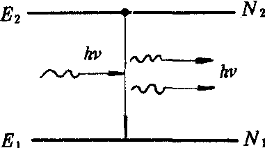
词条 | Deshler, Ohio |
释义 |
|official_name = Deshler, Ohio |settlement_type = Village |nickname = |motto = |image_skyline = Deshler elevator.jpg |imagesize = 250px |image_caption = Community grain elevator |image_flag = |image_seal = |image_map = OHMap-doton-Deshler.png |mapsize = 250px |map_caption = Location of Deshler, Ohio |image_map1 = Map of Henry County Ohio Highlighting Deshler Village.png |mapsize1 = 250px |map_caption1 = Location of Deshler in Henry County |subdivision_type = Country |subdivision_name = United States |subdivision_type1 = State |subdivision_name1 = Ohio |subdivision_type2 = County |subdivision_name2 = Henry |government_footnotes = |government_type = |leader_title = Mayor |leader_name = Stephen Gibson |leader_title1 = |leader_name1 = |established_title = |established_date = |unit_pref = Imperial |area_footnotes = [1] |area_magnitude = |area_total_km2 = 5.96 |area_land_km2 = 5.85 |area_water_km2 = 0.10 |area_total_sq_mi = 2.30 |area_land_sq_mi = 2.26 |area_water_sq_mi = 0.04 |population_as_of = 2010 |population_est = 1795 |pop_est_as_of = 2012[1] |population_footnotes = [3] |population_total = 1799 |population_density_km2 = 307.3 |population_density_sq_mi = 796.0 |timezone = Eastern (EST) |utc_offset = -5 |timezone_DST = EDT |utc_offset_DST = -4 |elevation_footnotes = [2] |elevation_m = 217 |elevation_ft = 712 |coordinates = {{coord|41|12|25|N|83|54|9|W|region:US_type:city|display=inline,title}} |postal_code_type = ZIP code |postal_code = 43516 |area_code = 419 |blank_name = FIPS code |blank_info = 39-21812[3] |blank1_name = GNIS feature ID |blank1_info = 1039681[2] |website = http://www.deshlerohiochamber.com/ |footnotes = }} Deshler is a village in Henry County, Ohio, United States. The population was 1,799 at the 2010 census. HistoryDeshler was platted in 1873, and named for John G. Deshler, the original owner of the town site.[4] A post office has been in operation at Deshler since 1872.[5] The village was incorporated in 1876.[6] GeographyDeshler is located at {{coord|41|12|25|N|83|54|9|W|type:city}} (41.207011, -83.902445).[7] According to the United States Census Bureau, the village has a total area of {{convert|2.30|sqmi|sqkm|2}}, of which {{convert|2.26|sqmi|sqkm|2}} is land and {{convert|0.04|sqmi|sqkm|2}} is water.[8] Deshler's street pattern is laid out around the railroad line.[9] CSX Transportation owns two lines (formerly Baltimore and Ohio and Chessie System) which run through the community (50 to 70 trains daily) and is popular with rail fans; a YouTube channel operates a continuous live webcast from the "diamond" intersection in addition to a "Crossroads Park" where trains can be observed.[10]Video[https://www.youtube.com/watch?v=akJFPVsF1pw Drone video of eastbound freight train through Deshler] [https://www.youtube.com/watch?v=b5eIj7-j0is Continuous live video of CSX rail intesection] Demographics{{US Census population|1880= 752 |1890= 1114 |1900= 1628 |1910= 1515 |1920= 1514 |1930= 1538 |1940= 1570 |1950= 1623 |1960= 1824 |1970= 1938 |1980= 1870 |1990= 1876 |2000= 1831 |2010= 1799 |estyear=2017 |estimate=1730 |estref=[11] |footnote=U.S. Decennial Census[12] }} 2010 censusAs of the census[13] of 2010, there were 1,799 people, 678 households, and 485 families residing in the village. The population density was {{convert|796.0|PD/sqmi|PD/km2|1}}. There were 771 housing units at an average density of {{convert|341.2|/sqmi|/km2|1}}. The racial makeup of the village was 91.9% White, 0.1% African American, 0.3% Native American, 0.4% Asian, 4.4% from other races, and 2.8% from two or more races. Hispanic or Latino of any race were 9.9% of the population. There were 678 households of which 37.6% had children under the age of 18 living with them, 51.6% were married couples living together, 12.4% had a female householder with no husband present, 7.5% had a male householder with no wife present, and 28.5% were non-families. 25.1% of all households were made up of individuals and 11.8% had someone living alone who was 65 years of age or older. The average household size was 2.60 and the average family size was 3.04. The median age in the village was 36.5 years. 28.8% of residents were under the age of 18; 6.5% were between the ages of 18 and 24; 26.5% were from 25 to 44; 23.1% were from 45 to 64; and 14.9% were 65 years of age or older. The gender makeup of the village was 49.5% male and 50.5% female. 2000 censusAs of the census[3] of 2000, there were 1,831 people, 702 households, and 504 families residing in the village. The population density was 808.8 people per square mile (312.8/km²). There were 755 housing units at an average density of 333.5 per square mile (129.0/km²). The racial makeup of the village was 93.99% White, 0.11% African American, 0.44% Native American, 0.76% Asian, 3.22% from other races, and 1.47% from two or more races. Hispanic or Latino of any race were 6.88% of the population. There were 702 households out of which 34.6% had children under the age of 18 living with them, 57.5% were married couples living together, 8.7% had a female householder with no husband present, and 28.1% were non-families. 24.8% of all households were made up of individuals and 13.1% had someone living alone who was 65 years of age or older. The average household size was 2.55 and the average family size was 3.02. In the village, the population was spread out with 27.0% under the age of 18, 8.6% from 18 to 24, 27.4% from 25 to 44, 20.1% from 45 to 64, and 16.9% who were 65 years of age or older. The median age was 35 years. For every 100 females there were 101.0 males. For every 100 females age 18 and over, there were 89.4 males. The median income for a household in the village was $36,897, and the median income for a family was $44,145. Males had a median income of $31,360 versus $23,810 for females. The per capita income for the village was $16,639. About 5.6% of families and 7.5% of the population were below the poverty line, including 9.3% of those under age 18 and 4.3% of those age 65 or over. EducationPublic education for the village is administered by the Patrick Henry Local School District.[14] Notable people
References1. ^{{cite web |title=Population Estimates |url=https://www.census.gov/popest/data/cities/totals/2012/SUB-EST2012.html |publisher=United States Census Bureau |accessdate=2013-06-17 |deadurl=yes |archiveurl=https://www.webcitation.org/6HQu4Spqa?url=http://www.census.gov/popest/data/cities/totals/2012/SUB-EST2012.html |archivedate=2013-06-17 |df= }} {{Henry County, Ohio}}2. ^1 {{cite web|url=http://geonames.usgs.gov|accessdate=2008-01-31|title=US Board on Geographic Names|publisher=United States Geological Survey|date=2007-10-25}} 3. ^1 {{cite web |url=http://factfinder2.census.gov |publisher=United States Census Bureau |accessdate=2008-01-31 |title=American FactFinder |deadurl=yes |archiveurl=https://web.archive.org/web/20130911234518/http://factfinder2.census.gov/ |archivedate=2013-09-11 |df= }} 4. ^{{cite book|last=Aldrich|first=Lewis Cass|title=History of Henry and Fulton Counties, Ohio|url=https://books.google.com/books?id=8SJEAQAAMAAJ&pg=PA200|year=1888|publisher=D. Mason & Company|page=200}} 5. ^{{cite web | url=http://www.postalhistory.com/postoffices.asp?task=display&state=OH&county=Henry | title=Henry County | publisher=Jim Forte Postal History | accessdate=12 December 2015}} 6. ^{{cite book|last=Aldrich|first=Lewis Cass|title=History of Henry and Fulton Counties, Ohio|url=https://books.google.com/books?id=8SJEAQAAMAAJ&pg=PA201|year=1888|publisher=D. Mason & Company|page=201}} 7. ^{{cite web|url=https://www.census.gov/geo/www/gazetteer/gazette.html|publisher=United States Census Bureau|accessdate=2011-04-23|date=2011-02-12|title=US Gazetteer files: 2010, 2000, and 1990}} 8. ^1 {{cite web |title=US Gazetteer files 2010 |url=https://www.census.gov/geo/www/gazetteer/files/Gaz_places_national.txt |publisher=United States Census Bureau |accessdate=2013-01-06 |deadurl=yes |archiveurl=https://www.webcitation.org/64vfLAeJ2?url=http://www.census.gov/geo/www/gazetteer/files/Gaz_places_national.txt |archivedate=2012-01-24 |df= }} 9. ^{{cite book | url=https://books.google.com/books?id=Gefpsoo1nRIC&lpg=PP1&pg=PA213#v=onepage&q&f=false | title=A Geography of Ohio | publisher=Kent State University Press | year=1996 | accessdate=8 December 2013 | author=Peacefull, Leonard | pages=213}} 10. ^{{cite web|title=Deshler, OH live stream|url=https://www.youtube.com/watch?v=tVGIXLoQ-Fw}} 11. ^{{cite web|url=https://www.census.gov/programs-surveys/popest/data/tables.2017.html|title=Population and Housing Unit Estimates|accessdate=May 26, 2018}} 12. ^{{cite web|url=https://www.census.gov/prod/www/decennial.html|title=Census of Population and Housing|publisher=Census.gov|accessdate=June 4, 2015|deadurl=yes|archiveurl=https://www.webcitation.org/6YSasqtfX?url=http://www.census.gov/prod/www/decennial.html|archivedate=May 12, 2015|df=}} 13. ^1 {{cite web|title=American FactFinder|url=http://factfinder2.census.gov/faces/nav/jsf/pages/index.xhtml|publisher=United States Census Bureau|accessdate=2013-01-06}} 14. ^{{cite web | url=http://www.henrycoelections.com/School_Districts.html | title=School districts | publisher=Henry County Board of Elections | accessdate=25 February 2018}} 1 : Villages in Henry County, Ohio |
随便看 |
|
开放百科全书收录14589846条英语、德语、日语等多语种百科知识,基本涵盖了大多数领域的百科知识,是一部内容自由、开放的电子版国际百科全书。