芥蓝Chinese kale:kailan
十字花科(Cruciferae)芸薹属中以花薹为产品的一二年生草本植物。学名Brassica alboglabra Bailey,别名白花芥蓝。中国特产蔬菜,以肥嫩的花薹和嫩叶供食用,质脆嫩、清甜。每100克产品中,含水分92~93克,维生素C51~68.8毫克,还含有蛋白质、碳水化合物和矿物质。芥蓝起源于中国南部,主要分布广东、广西、福建和台湾等省(区)。中国的北京、上海、南京、杭州等地有少量栽培。已传入日本、东南亚各国,以及欧、美、大洋洲。
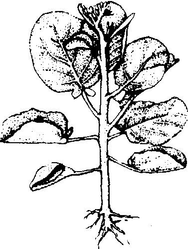
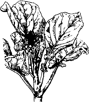
植物学性状 根系浅,主要根群分布15~20厘米的耕层内,再生能力较强。茎直立,绿色,较短缩。单叶互生,卵形、椭圆形或近圆形,叶面光滑或皱缩,浓绿色,被蜡粉;叶柄青绿色。初生花茎肉质,节间较疏,称为菜薹,绿色,供食用; 中后期,花茎伸长和分枝,形成复总状花序。完全花,花瓣白或黄色。雄蕊6、4强,雌蕊1。异花授粉,虫媒花。角果,含多数种子,种子近圆形,褐色至黑褐色,千粒重3.5~4克。
芥 蓝
生长发育和菜薹形成芥蓝的生育周期包括:❶发芽期:自播种至子叶展开,第一片真叶显露约需7~10天。
❷幼苗期: 自第一片真叶显露至第五片真叶展开,约需15~25天。适温下,幼苗期即开始花芽分化。
❸叶丛生长期: 第五片真叶展开至植株现蕾,一般需20~25天。叶片迅速生长,茎端发生花芽。
❹菜薹形成期:植株现蕾至菜薹形成。菜薹(主薹)采收后,基部腋芽可以形成侧薹。
❺开花结果期: 花茎不断伸长并分枝,陆续开花,花期1个月左右,初花至种子成熟约需75~90天。
芥蓝生长发育适温:发芽期和幼苗期为25~30℃,20℃以下生长缓慢。叶丛生长和菜薹形成适温为15~25℃,喜较大的昼夜温差,30℃以上高温,菜薹发育不良,15℃以下则发育缓慢。芥蓝属长日照植物,但现有品种对日照长度需求不严格。叶片生长,菜薹发育和开花结果都需要良好光照。芥蓝植株鲜重和干物重在叶丛生长期以前增加很少,菜薹形成期迅速增长。此期叶丛的干物质因逐渐转向菜薹而减少,采收时菜薹干物质占全株重的65%左右。芥蓝的早熟和中熟品种在27~28℃的较高温度下花芽能迅速分化,降低温度对花芽分化没有明显促进作用。晚熟品种对温度要求则比较严格,在较高温度下虽能花芽分化,但花芽分化延迟,较低温度和延长低温时间能促进花芽分化。花芽分化是菜薹形成的开始,菜薹的发育依赖营养器官的生长,菜薹重量与植株重量和叶面积大小成正相关。
类型与品种 芥蓝中有白花和黄花两种类型。黄花芥蓝只有少量栽培。白花芥蓝品种较多,栽培面积大,分布较广,并分为❶早熟类型: 较耐热,华南地区夏秋播种,9月至12月收获,产量较高。代表品种有细叶早芥蓝、皱叶早芥蓝和柳叶早芥蓝等。
❷中熟类型: 耐热性不如早熟类型,对低温适应性又不如晚熟类型。华南地区9月至11月播种,11月至翌年2月采收。主要品种有荷塘芥蓝、登峰芥蓝等。
❸晚熟类型:不耐热,不宜早播,冬性较强,适于冬春栽培。播种期10月至12月,采收期1月至4月,主要品种有铜壳叶芥蓝、迟花芥蓝、三元里迟芥蓝和皱叶迟芥蓝等。
栽培技术 芥蓝栽培应选择气温为15~25℃的季节,并选用相应的品种,因地制宜地确定播种期和收获期。芥蓝对土壤的适应性较广,以壤土和砂壤上为宜。直播或育苗移植。苗龄20~30天,5~6片真叶定植。株行距25~35厘米。
芥蓝对氮、磷、钾三要素的吸收量,以钾最多、氮其次、磷最少。氮、磷、钾比例为5.2:1:5.4。各个时期对氮、磷、钾的吸收量也不相同,以氮为例,幼苗期以前的吸收量占2.5%左右,叶丛生长期占10.3%,菜薹形成期占87.2%。对磷、钾、钙、镁的吸收动态与氮的吸收基本相同。定植前应施用腐熟厩肥作基肥,定植缓苗后和植株现蕾时及时追肥,促进植株和菜薹的生长,应注意氮、磷、钾肥配合施用。大部分主薹采收后,加强追肥促进侧薹形成。在侧薹采收过程还要继续追肥,才能延长采收期,提高产量。芥蓝喜湿润的土壤环境,须保持土壤田间持水量的80~90%为宜。雨天及时排除积水。菜薹包括薹叶和薹茎两部分,在菜薹形成过程中,前期以薹叶生长为主,后期薹茎生长占优势。薹茎较粗大,节间较疏,薹叶细嫩而少,为优质菜薹。薹高与叶片高度相同时,应及时采收。采收时在基部5~7叶节处割取,侧薹则应在第1~2叶节处割取,以保证菜薹质量。主薹一般采收15~25天,侧薹采收25~35天。
芥蓝易与甘蓝类蔬菜天然杂交,留种时要隔离。留种母株应具有本品种特征,要求抽薹整齐、菜薹肥大,皮薄、节疏、薹叶细小,花球紧密。每年进行株选和片选,可保持优良种性。
病虫害及其防治与大白菜、结球甘蓝同。
芥蓝Chinese kale
Brassica alboglabra Bailey.,又称白花芥蓝。十字花科,芸薹属。以花薹作食用的蔬菜。一二年生草本。栽培广,品种多。原产中国华南地区,现已传播到欧、美洲各国。茎粗壮、直立,分枝性强。叶较大,色蓝绿,叶缘波状或有小锯齿,基部常有叶翼,叶柄长、绿色。初生花茎肉质,节间较疏,称菜薹,色绿。中后期花茎伸长,分枝,形成复总状花序。喜温和湿润气候,适于黏壤土生长。华南地区可周年栽培,其他地区均在春秋两季栽培。以肥嫩花薹和嫩叶供食。
芥蓝