软化栽培blanching culture
将某一生长阶段的蔬菜栽植在黑暗(或弱光)和温暖潮湿的环境中,生长出具有独特风味产品的一种保护栽培方法。软化栽培的产品含有少量叶绿素,大多呈现白绿、黄、黄白或紫红等颜色,组织柔软或脆嫩,具有较高的商品价值,是冬、春季上市的鲜菜之一。
早在两千年前的《汉书·召信臣传》中就有利用原始温室进行葱、韭软化栽培的记载。元代王祯《农书》中记叙了用马粪、稻草灰覆盖韭菜的软化栽培方法。如“至冬,移根藏于地屋荫中,培以马粪,暖而即长”。这些方法以后在中国历代相传,至今仍有应用,只是在覆盖材料和软化方法上有许多改革和创造,而且软化栽培的蔬菜种类也逐渐增多,在中国蔬菜保护地生产中占有重要地位。日本在葱蒜类和叶菜类蔬菜的软化栽培方面有一定数量。欧洲和美洲一些国家常见的软化产品有石刁柏、苦苣等。
适宜作软化栽培的蔬菜种类很多,中国软化栽培主要是葱蒜类蔬菜,其次是叶菜类。葱蒜类蔬菜耐寒性强,在冬、春季不需很高的温度就能生产,其软化产品有韭黄和蒜黄,色泽金黄,质地脆嫩,味道变得较清淡而又不失葱蒜类特有的辛香味。根据蔬菜软化材料的植物学器官分类分为根茎类、地下茎、茎叶和种子等。
根茎类:韭菜、石刁柏、上当归、鸭儿芹、防风、蒲公英、食用大黄、葱、蒜、洋葱等;
地下茎: 姜、芋、薄荷、款冬、竹笋、蒲菜等:茎叶:芹菜、苦苣、菠菜、小白菜、乌塌菜、花椰菜等;
种子:豌豆、蚕豆、大豆、绿豆、萝卜、紫苏等。
中国软化蔬菜的方法主要有两类,一类是采用简易覆盖的方法创造软化栽培的条件,例如扣瓦盆、竹筒,覆盖马粪、树叶、麦糠、稻草等,或者培土。栽培特点是蔬菜生长前期在有光条件下正常生长,使根、根茎、嫩茎或鳞茎内储存大量营养物质,到一定生长阶段就地覆盖生长。用这种软化方式生产的产品有韭黄、蒜黄、姜芽、石刁柏等。另一类是在人工建造的设施内进行软化栽培,如利用冷床、温床、温室、塑料棚、地窖、井窖、窑洞(图1)等。四川省成都地区用稻草蓬(图2):陕西省和山西省利用窑洞;北京地区设软化温室(图3);河北省保定地区利用井窖;山东省济南地区利用地窖等生产韭黄、青韭、蒜黄。
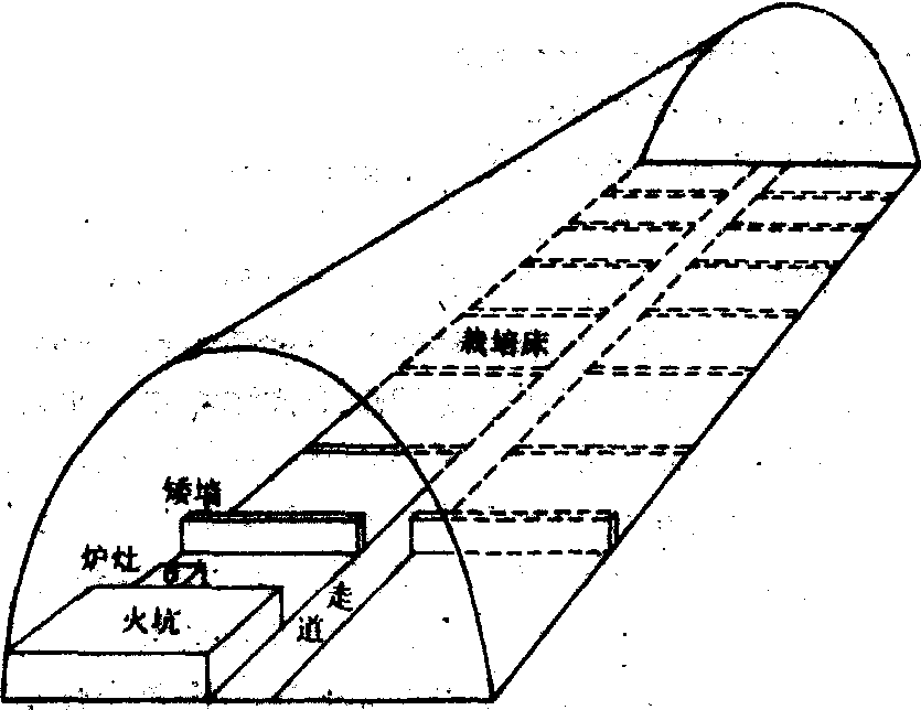
图1 窑洞示意图
用温室软化栽培的:这种温室比一般的栽培温室矮,栽培床较宽,三面为墙,仅南侧为采光面。采光材料一般为油纸或塑料薄膜,夜间加盖草苫。温室中央设有炉灶加温(没有烟道和烟囱),栽培床在地表以下。室内气温可经常保持25℃左右,夜间比白天要高2~3℃。相对湿度75~80%,这样的温室栽植韭菜的根茎,每20天可收割一次青韭。这种温室逐渐减少,而被塑料薄膜温室所代替,但在室内要加盖黑色薄膜或草苫。
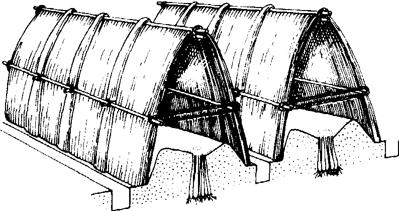
图2 稻草蓬软化韭菜示意图
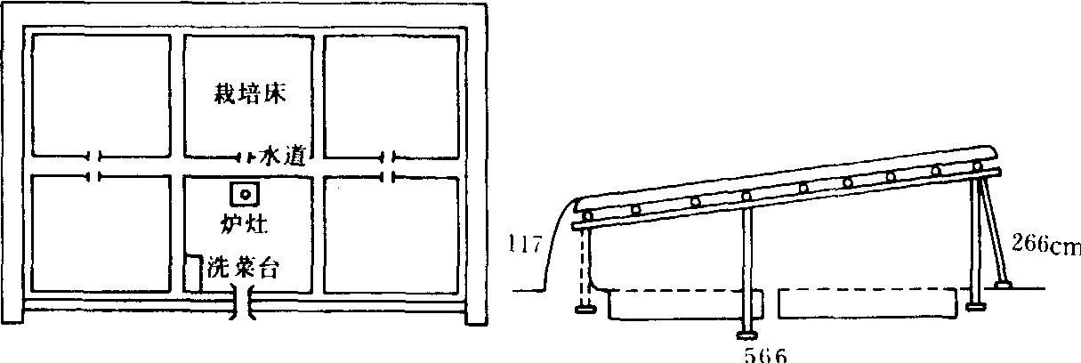
图3 软化温室栽培畦平面布局(左)和断面(右)示意图
用窑洞软化栽培的:一般建在背风向阳处。窑洞宽3.3米,高2米,长11~33米。窑口用砖或土坯封住仅留一小门。门内建有火炉或火炕等补充加温设备,中央有走道,两侧为软化栽培床。此窑内温度变化小,能经常保持15℃以上,韭菜根茎萌芽后15天左右就可收割一次韭黄。人工加温时燃料燃烧可能产生大量的一氧化碳和二氧化碳以及二氧化硫等,不但降低商品质量,而且对人体有害,在栽培时要注意通风换气。
软化栽培是保护地生产中特殊的栽培方法。在栽培管理中要注意: ❶预先要培养健壮的植株,或具有丰富营养的贮藏器官,以供软化生长中对养分的需要。
❷不必有较大的昼夜温差,以求快速生长,但在不同生长阶段要求的温度不同,温度过高,则产量低而质量差。
❸既要有较高的空气湿度和土壤湿度,又要注意适当通风,管理不善易发生腐烂现象。
❹根据商品质量要求分期培土,调节光照,以得到不同颜色的软化产品。
❺必要时,适时适量追肥,以促进生长。
软化栽培
指对蔬菜的营养器官采取培土、覆盖或放入地窖等措施,使茎叶不见光,叶绿素消失,组织柔嫩,纤维减少,以提高其品质和风味的一种栽培方法。如韭黄、蒜黄等即是经软化栽培的产品。
软化栽培blanching culture
将某一生长阶段的蔬菜栽培在黑暗和温暖潮湿的环境中,生长出具有独特风味、柔嫩或脆嫩产品的一种保护地栽培方式。中国,早在两千年前就有利用原始温室进行葱、韭软化栽培的记载。软化栽培主要包括韭黄、蒜黄、大葱、菊苣和芹菜等。方法有培土、覆盖、缚叶或将根株移入地窖、温室等设施,造成黑暗的环境,并保持适当的温湿度,使茎叶失绿,质地柔软脆嫩,有较高的商品价值。