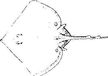
词条 | Borough of Wyre | ||||||||||||||||||||
释义 |
|name = Borough of Wyre |type = Borough |image_skyline = |imagesize = |image_caption = |image_blank_emblem= |blank_emblem_type = Coat of Arms of the City Council |image_map = Wyre UK locator map.svg |map_caption = Wyre shown within Lancashire and England |subdivision_type = Sovereign state |subdivision_name = United Kingdom |subdivision_type1 = Constituent country |subdivision_name1 = England |subdivision_type2 = Region |subdivision_name2 = North West England |subdivision_type3 = Ceremonial county |subdivision_name3 = Lancashire |seat_type = Admin. HQ |seat = Poulton-le-Fylde |government_type = Wyre Borough Council |leader_title = Leadership: |leader_name = Leader & Cabinet |leader_title1 = Executive: |leader_name1 = {{English district control|GSS=E07000128}} |leader_title2 = MPs: |leader_name2 = Paul Maynard, Cat Smith, Ben Wallace |leader_title3 = |leader_name3 = |established_title = Founded |established_date = 1974 |founder = |area_rank = {{English district area rank|GSS=E07000128}} |area_total_km2 = {{formatnum:{{English district area|GSS=E07000128}}|R}} |area_footnotes = [1] |latd= |latm= |lats= |latNS= |longd= |longm= |longs= |longEW= |population_as_of = {{English statistics year}} |population_total = {{English district population|GSS = E07000128}} |population_rank = {{English district rank|GSS=E07000128}} |population_density_km2 = auto |population_footnotes = [2] |timezone = Greenwich Mean Time |utc_offset = +0 |timezone_DST = British Summer Time |utc_offset_DST = +1 |postal_code_type = Postcode |postal_code = |area_code = |blank_name = ISO 3166-2 |blank_info = |blank1_name = ONS code |blank1_info = 30UQ (ONS) E07000128 (GSS) |blank2_name = OS grid reference |blank2_info = |blank3_name = NUTS 3 |blank3_info = |blank4_name = Ethnicity |blank4_info = 96.6% White 1.9% S.Asian[3] |website = wyre.gov.uk }} Wyre is a local government district with borough status in Lancashire, England. The population of the non-metropolitan district at the 2011 census was 107,749.[4] The district borders the unitary authority of Blackpool as well as the districts of Lancaster, Ribble Valley, Fylde and Preston. The council is based in Poulton-le-Fylde. The district is named after the River Wyre, which runs through the district. It was formed on 1 April 1974 by the Local Government Act 1972 and was a merger of the municipal borough of Fleetwood, along with Poulton-le-Fylde, Preesall, Garstang and Thornton-Cleveleys urban districts and various rural districts. {{Location map+|United Kingdom Borough of Wyre| caption= | float=right | width=600 | places = {{Location map~|United Kingdom Borough of Wyre|lat=53.923|long=-3.015|label='''Fleetwood''' |position=bottom|marksize=12|label_size=100}} {{Location map~|United Kingdom Borough of Wyre|lat=53.847|long=-2.995|label='''Poulton-le-Fylde'''|marksize=12|label_size=100}} {{Location map~|United Kingdom Borough of Wyre|lat=53.871|long=-3.004|label='''Thornton'''|position=bottom|marksize=12|label_size=100}} {{Location map~|United Kingdom Borough of Wyre|lat=53.881|long=-3.040|label='''Cleveleys'''|marksize=12|label_size=100}} {{Location map~|United Kingdom Borough of Wyre|lat=53.903|long=-2.771|label='''Garstang'''|position=left|marksize=12|label_size=100}} {{Location map~|United Kingdom Borough of Wyre|lat=53.854|long=-2.744|label=Bilsborrow|label_size=85|}} {{Location map~|United Kingdom Borough of Wyre|lat=53.902|long=-2.651|label=Bleasdale|label_size=85|position=left}} {{Location map~|United Kingdom Borough of Wyre|lat=53.897|long=-2.771|label=Bonds|label_size=85|}} {{Location map~|United Kingdom Borough of Wyre|lat=53.889|long=-2.767|label=Bowgreave|label_size=85|}} {{Location map~|United Kingdom Borough of Wyre|lat=53.906|long=-2.711|label=Calder Vale|label_size=85|position=left}} {{Location map~|United Kingdom Borough of Wyre|lat=53.854|long=-3.007|label=Carleton|label_size=85|position=left}} {{Location map~|United Kingdom Borough of Wyre|lat=53.880|long=-2.763|label=Catterall|label_size=85|}} {{Location map~|United Kingdom Borough of Wyre|lat=53.880|long=-2.792|label=Churchtown|label_size=85|position=left}} {{Location map~|United Kingdom Borough of Wyre|lat=53.876|long=-2.722|label=Claughton|label_size=85|position=right}} {{Location map~|United Kingdom Borough of Wyre|lat=53.975|long=-2.733|label=Dolphinholme |label_size=85|position=left}} {{Location map~|United Kingdom Borough of Wyre|lat=53.900|long=-2.868|label=Eagland Hill|label_size=85|position=bottom}} {{Location map~|United Kingdom Borough of Wyre|lat=53.955|long=-2.782|label=Forton|label_size=85}} {{Location map~|United Kingdom Borough of Wyre|lat=53.855|long=-2.871|label=Great Eccleston|label_size=85|position=bottom}} {{Location map~|United Kingdom Borough of Wyre|lat=53.875|long=-2.954|label= Hambleton|label_size=85|position=top}} {{Location map~|United Kingdom Borough of Wyre|lat=53.834|long=-2.816|label=Inskip|label_size=85}} {{Location map~|United Kingdom Borough of Wyre|lat=53.927|long=-2.987|label=Knott End|label_size=85|}} {{Location map~|United Kingdom Borough of Wyre|lat=53.896|long=-2.817|label=Nateby|label_size=85|position=bottom}} {{Location map~|United Kingdom Borough of Wyre|lat=53.920|long=-2.703|label=Oakenclough|label_size=85|position=right}} {{Location map~|United Kingdom Borough of Wyre|lat=53.868|long=-2.907|label=Out Rawcliffe|label_size=85}} {{Location map~|United Kingdom Borough of Wyre|lat=53.929|long=-2.908|label=Pilling|label_size=85}} {{Location map~|United Kingdom Borough of Wyre|lat=53.921|long=-2.967|label=Preesall|label_size=85}} {{Location map~|United Kingdom Borough of Wyre|lat=53.863|long=-2.821|label= {{Location map~|United Kingdom Borough of Wyre|lat=53.919|long=-2.615|label=''Fair Snape Fell''|label_size=85|position=bottom|mark=Green Fire.svg}} {{Location map~|United Kingdom Borough of Wyre|lat=53.957|long=-2.645|label=''Hawthornthwaite Fell''|label_size=85|position=bottom|mark=Green Fire.svg}} {{Location map~|United Kingdom Borough of Wyre|lat=53.899|long=-2.617|label=''Parlick''|label_size=85|position=bottom|mark=Green Fire.svg}} }} Town and Parish CouncilsUrban areas
Civil parishes
Local elections{{Main|Wyre local elections}}Elections to Wyre Borough Council take place every four years on the first Thursday in May. All 55 councillors are elected from 26 wards. Since the formation of the council in 1973 it has been under the control of the Conservative Party with the exception of one term from 1995 to 1999 when the Labour Party held control of the council. Following the most recent election held on 5 May 2015 the composition of the council is as follows:
ParliamentWyre is split into three Parliamentary Constituencies - Wyre and Preston North, Lancaster and Fleetwood and Blackpool North and Cleveleys. This was recently changed as part of the Boundary changes for the United Kingdom general election, 2010. Before this change it had been split into three Lancaster and Wyre, Blackpool North and Fleetwood and Fylde. External links
References1. ^{{United Kingdom district population citation|area}} {{Borough of Wyre}}{{Borough of Wyre buildings}}{{Borough of Wyre culture}}{{NW_England}}{{Lancashire}}{{DEFAULTSORT:Wyre, Borough of}}2. ^{{United Kingdom district population citation|England}} 3. ^{{cite web | title = Resident Population Estimates by Ethnic Group (Percentages) | publisher = Office for National Statistics | date = 30 October 2007 | url = http://www.neighbourhood.statistics.gov.uk/dissemination/LeadTableView.do?a=3&b=277027&c=wyre&d=13&e=13&g=464712&i=1001x1003x1004&m=0&r=1&s=1206542374718&enc=1&dsFamilyId=1812 | accessdate = 2008-08-26}} 4. ^{{cite web|url=http://www.neighbourhood.statistics.gov.uk/dissemination/LeadKeyFigures.do?a=7&b=6275325&c=Wyre&d=13&e=62&g=6443583&i=1001x1003x1032x1004&m=0&r=1&s=1453562060203&enc=1|title=Non-Metropolitan District population 2011|accessdate=23 January 2016}} 5. ^{{cite web|url=http://www.wyre.gov.uk/councillors|title=Councillors|first=Frankie|last=Hughes|date=|website=www.wyre.gov.uk|accessdate=8 April 2018}} 4 : Borough of Wyre|Local government in the Borough of Wyre|Non-metropolitan districts of Lancashire|Local government districts of North West England |
||||||||||||||||||||
随便看 |
|
开放百科全书收录14589846条英语、德语、日语等多语种百科知识,基本涵盖了大多数领域的百科知识,是一部内容自由、开放的电子版国际百科全书。