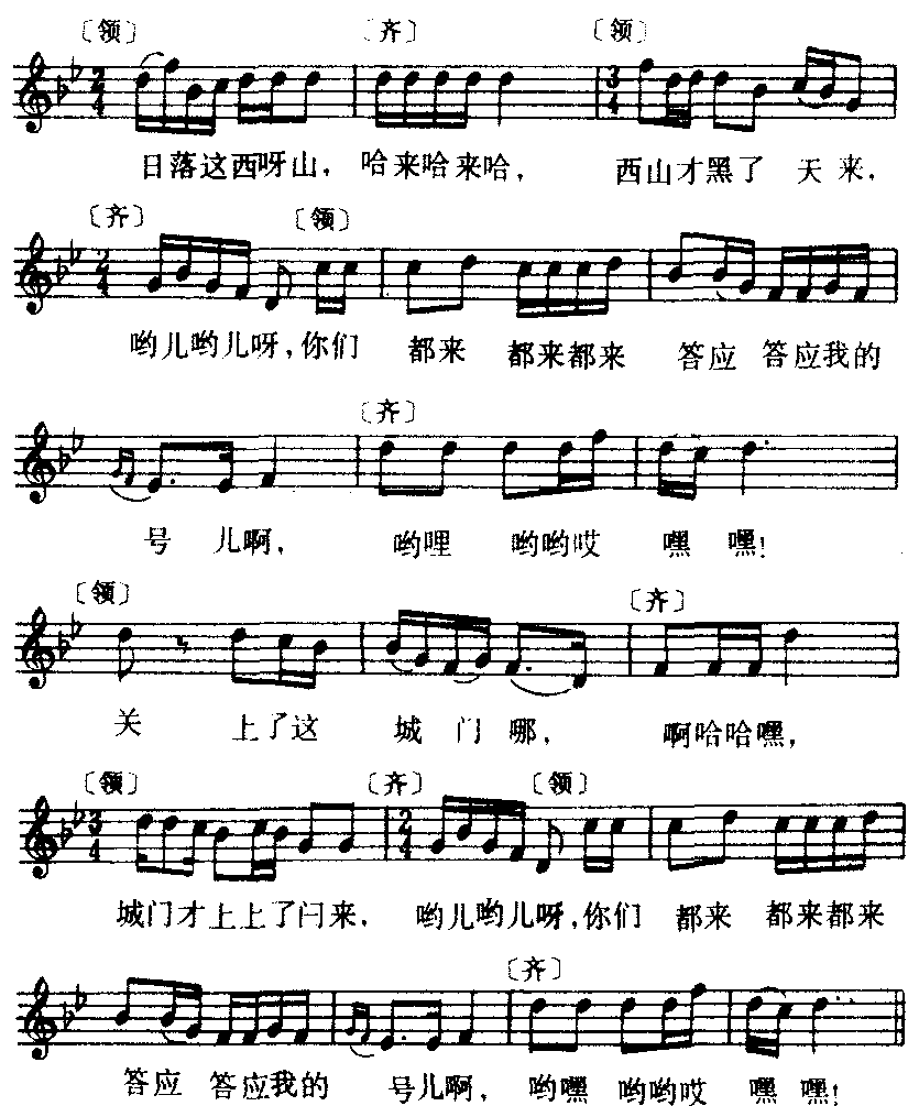
词条 | Charles B. Wheeler Downtown Airport |
释义 |
| name = Charles B. Wheeler Downtown Airport | image = FlyMKC airport logo.png | image-width = 189 | IATA = MKC | ICAO = KMKC | FAA = MKC | type = Public | owner-oper = Kansas City Aviation Department | city-served = Kansas City, Missouri | location = | elevation-f = 757 | website = [https://web.archive.org/web/20070622111715/http://www.flymkc.com/ www.FlyMKC.com] | coordinates = {{coord|39|07|23|N|094|35|34|W|region:US-MO|display=inline,title}} | pushpin_map = USA Missouri#USA | pushpin_relief = yes | pushpin_map_caption = Location | pushpin_label = MKC | pushpin_label_position = right | r1-number = 1/19 | r1-length-f = 6,827 | r1-surface = Concrete | r2-number = 3/21 | r2-length-f = 5,050 | r2-surface = Asphalt | stat-year = 2011 | stat1-header = Aircraft operations | stat1-data = 67,793 | stat2-header = Based aircraft | stat2-data = 189 | footnotes = Source: Federal Aviation Administration[1] }}Charles B. Wheeler Downtown Airport {{airport codes|MKC[2]|KMKC|MKC}} is a city-owned, public-use airport serving Kansas City, Missouri.[1] Located in Clay County,[1] this facility is included in the National Plan of Integrated Airport Systems, which categorized it as a general aviation reliever airport.[3] HistoryThis airport replaced Richards Field as Kansas City's main airport. It was dedicated as New Richards Field in 1927 by Charles Lindbergh and was soon renamed Kansas City Municipal Airport. Its prominent tenant was Trans World Airlines (TWA), which was headquartered in Kansas City. The airport was built in the Missouri River bottoms next to the rail tracks at the Hannibal Bridge. At the time air travel was considered to be handled in conjunction with rail traffic. The airport had limited area for expansion (Fairfax Airport across the Missouri River in Kansas City, Kansas covered a larger area). Airplanes had to avoid the {{convert|200|ft|m|-1|adj=on}} Quality Hill and the Downtown Kansas City skyline south of the south end of the main runway. In the early 1960s an FAA memo called it "the most dangerous major airport in the country" and urged that no further federal funds be spent on it. Kansas City replaced the airport in 1972 with Kansas City International Airport. The April 1957 Official Airline Guide (OAG) showed:
The downtown airport has been renamed for Charles Wheeler who was mayor when Kansas City International opened. Richards Road, which serves the airport, is named for John Francisco Richards II, a Kansas City airman killed in World War I (and whose name was also applied to Richards Field and Richards-Gebaur Air Force Base). Despite concerns about the airport being unsafe, Air Force One frequently uses it during Presidential visits. Today the airport is used for corporate and recreational aviation. The terminal building today houses VML, a global advertising and marketing agency headquartered in Kansas City. Its location near downtown has excellent highway access. It is home to the National Airline History Museum. Though the National Airline History Museum primarily contains artifacts from TWA (due to most of its volunteers are local retired TWA employees), the museum is dedicated to airline history in general. The TWA Museum is housed in the original Terminal that it was founded in at 10 Richards Road and is dedicated to the History of TWA. The airport also hosts the Aviation Expo (Air Show), most years, usually in August. FacilitiesThe airport covers 700 acres (283 ha) at an elevation of 757 feet (231 m).[1] It has two runways: 1/19 is 6,827 by 150 feet (2,081 x 46 m) concrete[1] with an EMAS at both ends.[4] 3/21 is 5,050 by 100 feet (1,539 x 30 m) asphalt.[1] Construction on runway 1-19 is complete and both runways are in use to their full length. Taxiway H was at one time part of runway 17/35, which was closed after an FAA decision on the required separation between terminal buildings and the runway. The airport is on the north side of the confluence of the Kansas River and Missouri River. Levees protected the airport relatively well during the Great Flood of 1951 and the Great Flood of 1993 although there was standing water. The 1951 flood devastated the Fairfax airport and caused Kansas City to build what would become Kansas City International Airport away from the river to keep the TWA overhaul base in the area after it had been destroyed in the flood at Fairfax. Kansas City, MO Aviation Department announced plans on October 17, 2006 to build a $20 million aircraft hangar complex at the Charles B. Wheeler Downtown Airport including: 122 T-hangars, 13 box hangars, a {{convert|40000|sqft|m2|-3|adj=on}} terminal building with offices, a pilots' lounge, meeting rooms and a destination restaurant. In the year ending September 30, 2011 the airport had 67,793 aircraft operations, average 185 per day: 71.5% general aviation, 26% air taxi, 2.2% military, and 0.3% airline. 189 aircraft were then based at the airport: 47.6% single-engine, 28.6% multi-engine, 22.2% jet, and 1.6% helicopter.[1] Cargo{{Airport-dest-list|AirNet Express | Columbus-Rickenbacker}} Accidents and incidents
See also
References1. ^1 2 3 4 5 6 {{FAA-airport|ID=MKC|use=PU|own=PU|site=11816.*A}}. Federal Aviation Administration. Effective November 15, 2012. 2. ^{{cite web | url = http://www.iata.org/publications/Pages/code-search.aspx | title = Airline and Airport Code Search (MKC: Kansas City / Downtown) | publisher = International Air Transport Association (IATA) | accessdate = March 14, 2014}} 3. ^ {{cite web |url=http://www.faa.gov/airports/planning_capacity/npias/reports/media/2011/npias_2011_appA.pdf |title=2011–2015 NPIAS Report, Appendix A |format=PDF, 2.03 MB |work=faa.gov |publisher=Federal Aviation Administration |date=October 4, 2010 |deadurl=yes |archiveurl=https://web.archive.org/web/20120927084535/http://www.faa.gov/airports/planning_capacity/npias/reports/media/2011/npias_2011_appA.pdf |archivedate=2012-09-27 |df= }} 4. ^{{cite web | url = http://www.kansascity.com/115/story/1554028.html | title = Downtown airport boasts a new runway safety system | publisher = KansasCity.com | date = November 6, 2009}} 5. ^{{cite news | url = http://www.kmbc.com/news/28926313/detail.html | title = Pilot Dies In KC Air Show | publisher = KMBC | date = August 20, 2011 | accessdate = August 20, 2011 | deadurl = yes | archiveurl = https://web.archive.org/web/20120322003008/http://www.kmbc.com/news/28926313/detail.html | archivedate = March 22, 2012 | df = }} 6. ^{{cite web | url = http://www.kctv5.com/story/23052325/human-remains-found-at-downtown-airport | title = Human remains found at KC downtown airport | publisher = KCTV | date = August 5, 2013}} External links
6 : Airports in Missouri|Transportation in Clay County, Missouri|Transportation buildings and structures in Kansas City, Missouri|Buildings and structures in Clay County, Missouri|Airports established in 1927|Airfields of the United States Army Air Forces in Missouri |
随便看 |
|
开放百科全书收录14589846条英语、德语、日语等多语种百科知识,基本涵盖了大多数领域的百科知识,是一部内容自由、开放的电子版国际百科全书。