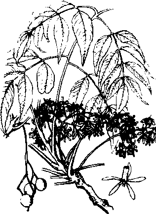
词条 | Cotopaxi Province | ||||||||||||||||||||||||||||||||
释义 |
|name = Cotopaxi |official_name = Province of Cotopaxi |other_name = |native_name = |native_name_lang = |nickname = |settlement_type = Province |total_type = |motto = |image_flag = Bandera Provincia Cotopaxi.svg |flag_size = |image_seal = |seal_size = |image_shield = |shield_size = |image_blank_emblem = |blank_emblem_type = |blank_emblem_size = |image_map = Cotopaxi in Ecuador (+Galapagos).svg |mapsize = |map_caption = Location of Cotopaxi in Ecuador. |image_map1 = Cantones de la Provincia de Cotopaxi.JPG |mapsize1 = |map_caption1 = Cantons of Cotopaxi Province |image_dot_map = |dot_mapsize = |dot_map_caption = |dot_x = |dot_y = |subdivision_type = Country |subdivision_name = Ecuador |seat_type = Capital |seat = Latacunga |parts_type = Cantons |parts_style = coll |parts = List of Cantons |p1 = La Maná |p2 = Latacunga |p3 = Pangua |p4 = Pujilí |p5 = Salcedo |p6 = Saquisilí |p7 = Sigchos |government_footnotes = |government_type = |leader_party = |leader_title = Provincial Prefect |leader_name = César Umaginga |leader_title1 = |leader_name1 = |established_title = |established_date = |extinct_title = |extinct_date = |founder = |named_for = |area_magnitude = |unit_pref = Metric |area_footnotes = |area_total_km2 = 6108.23 |area_land_km2 = |area_water_km2 = |area_total_sq_mi = |area_land_sq_mi = |area_water_sq_mi = |area_water_percent = |area_blank1_title = |area_blank1_km2 = |area_blank1_sq_mi = |elevation_footnotes = |postal_code_type = |postal_code = |postal2_code_type = |postal2_code = |area_code_type = |area_code = |registration_plate = X |blank_name_sec1 = |blank_info_sec1 = |blank1_name_sec1 = |blank1_info_sec1 = |website = {{URL|http://www.cotopaxi.gov.ec/}} |footnotes = }} Cotopaxi ({{IPA-es|kotoˈpaksi}}) is one of the provinces of Ecuador. The capital is Latacunga. The province contains the Cotopaxi Volcano, an intermittent volcano with a height of 19,388 feet. CantonsThe province is divided into 7 cantons.[2] The following table lists each canton with its population (per the 2001 census), its area in square kilometres (km²), and the name of the canton seat (capital).[3]
DemographicsEthnic groups as of the Ecuadorian census of 2010:[4]
See also{{commons category|Cotopaxi Province}}
References1. ^ tags-->|elevation_max_footnotes= |elevation_min_footnotes= |elevation_m =|elevation_ft =|elevation_max_m =|elevation_max_ft =|elevation_min_m =|elevation_min_ft =|population_as_of = 2010 census|population_footnotes =|population_note =|population_total = 409205|population_density_km2 = auto|population_density_sq_mi =|population_est =|pop_est_as_of =|population_density_blank1_km2 = |population_density_blank1_sq_mi =|timezone1 = |utc_offset1 = |coor_pinpoint = |coordinates = {{coord|0|56|S|78|37|W|display=inline,title}}| blank_name_sec2 = HDI (2017)| blank_info_sec2 = 0.722{{Cite web|url=https://es.scribd.com/document/398970547/Indice-de-Desarrollo-Humano-en-Ecuador|title=Human Development Index in Ecuador|access-date=2019-02-05|last=Villalba|first=Juan|website=Scribd|language=es}} 2. ^{{citation|title=Ecuador and the Galapagos Islands|author1=Danny Palmerlee |author2=Michael Grosberg |author3=Carolyn McCarthy |year= 2006|publisher=Lonely Planet|isbn=174104295X}} 3. ^Cantons of Ecuador. Statoids.com. Retrieved 4 November 2009. 4. ^ External links
2 : Cotopaxi Province|Provinces of Ecuador |
||||||||||||||||||||||||||||||||
随便看 |
|
开放百科全书收录14589846条英语、德语、日语等多语种百科知识,基本涵盖了大多数领域的百科知识,是一部内容自由、开放的电子版国际百科全书。