硅氧烷型表面siloxane-type surface
2:1型层状硅酸盐矿物中的基面。它是由一层氧离子和紧位于其下面的硅离子层组成,由于以Si-O-Si键键合,故称为硅氧烷型表面。云母的基面是最典型的,蒙皂石、蛭石及它们的间层矿物的基面也都是这种类型。高岭石和其它1:1型粘土矿物具有硅氧烷型表面和水合氧化物型表面两种基本表面,主要取决于晶体解理的位置。硅氧烷型表面带永久负电荷。其电荷主要来源于晶体结构内部离子的同晶置换,即晶格中部分四面体的Si4+被Al3+或八面体中Al3+被Mg2+置换。由于电荷是由晶格内部原因引起的,表面电荷与周围介质的性质(如pH和电解质浓度等)无关,则表面趋于恒电荷或永久电荷。所以硅氧烷型表面,按其表面电荷特性,也称为永久电荷表面或恒电荷表面。硅氧烷型表面与水的反应,主要取决于交换性阳离子的水合作用,表面水合也起一定作用。对低电荷的2:1型层状硅酸盐矿物,如叶腊石和滑石,这种由硅离子层和氧离子层组成的硅氧烷型表面,不易离解,硅离子的数目可足以使层片几乎没有电荷,表面是非极性疏水的。对高电荷的2:1型层状硅酸盐矿物,如云母、蛭石和蒙皂石,其表面上交换性阳离子与水强烈反应。最初吸附一水合壳,然后水分子进一步与水合壳中水氢键键合,或与粘粒表面中氧成弱氢键键合。
硅氧烷型表面siloxane surface
土粒表面类型之一。由硅氧四面体片的硅氧烷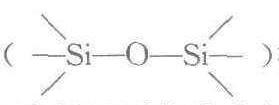 构成的表面。2:1 型矿物的单元晶层是两个硅氧四面体片中间夹一个八面体片,因此暴露的基面是硅氧四面体片的硅氧烷。土壤中的云母以及水云母、蒙皂石、蛭石等2:1型矿物的表面均属硅氧烷型。1:1型矿物(如高岭石)的1/2基面也属硅氧烷型表面。硅离子与氧离子组成的硅氧烷型表面不易离解,是疏水性表面,其电荷来源除断键外,主要靠Si4+被Al3+置换而产生的永久负电荷。