硫丹endosulfan
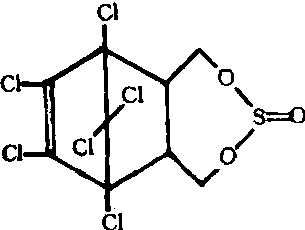
无累积性毒性、用于旱地的有机氯杀虫剂。化学结构式:
性能 产品为两种空间异构体的混合物,异构体Ⅰ熔点108~109℃,异构体Ⅱ熔点206~208℃,两种异构体的比例:Ⅰ:Ⅱ为2:1。工业原药为浅棕色结晶,具有二氧化硫的气味,熔点70 ~ 100 ℃,密度d204 1.745,25℃时 气压为0.002帕,不溶于水,中度溶解于大多数有机溶剂。对日光稳定,遇酸、碱、水汽分解,放出二氧化硫,对铁有腐蚀性。对高等动物毒性较高,大鼠急性口服LD50为40~50毫克/千克。含30毫克/千克硫丹的饲料,喂大鼠两年,无不良影响,对鱼高毒。对蜜蜂安全。具有胃毒和触杀作用,杀虫广谱,残效较长。
应用 适用于防治棉花、果树、蔬菜、烟草、马铃薯及苜蓿上的多种咀嚼式和刺吸式口器害虫。对作物不易产生药害。常用20%乳油300~500倍液喷雾,防治棉铃虫、红铃虫、棉卷叶虫、金刚钻、金龟子、梨小食心虫、桃小食心虫、粘虫、蓟马和叶蝉等。用500~1000倍液,可防治棉花和果树上的蚜、螨。用200倍液灌根防治地老虎效果也很好。残留限量为2毫克/千克,作物收获前三周禁止使用,对鱼高毒,不能在水田使用。
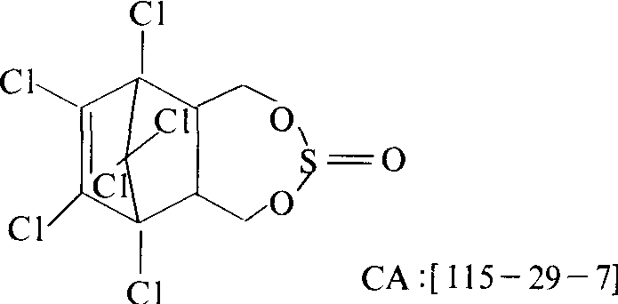
硫丹endosulfan
广谱有机氯杀虫剂。化学名称:6,7,8,9,10,10-六氯-1,5,5a,6,9,9a-六氢-6,9-甲撑-2,4,3-苯并〔e〕二氧硫庚-3-氧化物。化学结构式如下。工业品浅棕色结晶固体,具有二氧化硫的气味,是两种异构体的混合物,a异构体约含70%,β异构体含30%。熔点70~100℃,密度1.745,25℃时蒸气压133.322×10⁻⁵ Pa。不溶于水,较易溶于有机溶剂。对日光稳定,遇酸、碱及湿气分解,放出二氧化硫。对铁有腐蚀性。对昆虫有触杀和胃毒作用,无内吸性。可用于防治棉、玉米、烟草、果树等作物上的蚜虫、棉铃虫、食心虫、黏虫、卷叶虫。工业品对大鼠口服LD50为80~110 mg/kg,a异构体为76 mg/kg,β异构体为240 mg/kg。在植物体内半衰期3~7天,在人、畜体内不积累。对鱼高毒。