负荷车dynamometer vehicle
用于对所牵引的汽车、拖拉机及工程机械等被测车辆施加可调的、平稳的牵引阻力,以测定和记录牵引试验各参量的专用车辆。1929年苏联拖拉机科学研究所(HATH)用拖拉机改装了机械制动式负荷车。20世纪70年代以来,负荷车相继采用了电涡流制动器、排气制动等吸功(加载)装置,非电量电测仪器系统和自控装置以及微处理机数据处理装置等装备。
特点和要求 用于汽车、拖拉机牵引试验的负荷车应满足:产生的牵引阻力与地面平行并与被测车辆保持轴向跟踪;牵引阻力调节范围大,平稳可靠,能方便地实现无级调节;负荷特性(即牵引阻力——速度特性)与被测车辆的牵引特性相适应;仪器的测试精度及配套合适,试验过程能实现自动同步测量与程序控制等技术要求;具有可供试验人员乘坐和安装测量仪器的车厢。
构成 负荷车可用四轮驱动拖拉机、全轴驱动汽车、牵引车和集材车等底盘改装。通常将吸功装置和测试控制仪表安装在同一台车辆上。随着被测车辆功率的增加,也可采用负荷列车以增大加载能力,这时可将测试控制仪表配置在第一负荷车上,加挂的其它车辆仅安装吸功装置(图1)。
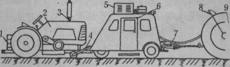
图1 负荷车示意图
1. 荷重; 2. 负荷车; 3. 排气制动阀; 4. 第五轮; 5. 空调装置; 6. 仪表车厢; 7. 拉力仪;8. 转速测定装置; 9. 被测车辆
吸功装置 是负荷车产生牵引阻力的主要设备。试验时汽车、拖拉机等通过牵引杆拖曳负荷车等速前进。负荷车的车轮与试验路面附着力经传动系统传到吸功装置的轴上,与吸功装置产生的阻力矩相平衡。调节此阻力矩数值就能对被测车辆产生可调节的平稳的牵引阻力。负荷车的吸功装置可采用电力式(电涡流制动器、直流发电机等)、液力式(液压油泵和液压系统节流阀控制)、气力式(利用发动机排气节流)、机械式(内燃机及摩擦制动器)及其混合形式的加载设备。其中风冷式电涡流制动器(图2)具有重量轻,结构紧凑,吸收功率大,便于自动控制等特点,应用日趋广泛。有的负荷车为保证车轮与试验路面稳定的附着性能,设有清洁试验跑道的吹风清扫装置。
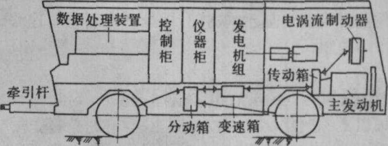
图2 以电涡流制动器为吸功装置的负荷车
测试仪器 包括各种传感器、二次仪表、数据处理装置及控制系统(图3)。牵引试验所测量的参数及匹配仪器主要有: ❶测量牵引力用液压自记拉力仪、电拉力仪或在牵引杆(牵引杆应具有保持水平免受弯曲载荷的结构)内设置拉力传感器。
❷测量行驶速度用第五轮。它可以准确测出车辆的行驶距离、时间和速度。第五轮是通过轮架固定在负荷车上贴着地面自由滚动的轮子,并带具有一定齿数齿盘的磁电式传感器或具有一定孔数孔盘的光电式传感器,将行驶距离转换为断续脉冲电信号,然后输送给计数器,每一脉冲相当于一定行驶距离,由计时器同步测得行驶时间,经运算得到行驶速度;还可在试验跑道固定测区的两端涂以白色反光横线,用安装在负荷车下端的光电触发系统控制计时器的启与停,依此求出行驶速度;用多普勒雷达测速仪或光电测速仪等能测出负荷车的瞬时行驶速度。
❸测量燃油消耗量的装置有量管式燃油油耗仪、活塞式油耗仪和组合式油耗仪。后者由流量传感器、油温传感器和微处理机组成。
❹测定发动机、驱动轮或动力输出轴转数的设备常用可产生60个(或若干个)电脉冲信号的磁电式或光电式传感器。
❺测量滑转率的装置。可由待测车辆空车和负载驶过测区时测得的动力输出轴转数(左右驱动轮的平均转数)或行驶速度计算而得。其它还有测量噪声、油温、相对湿度、大气压力等仪表。有的还配有专用型或通用型多功能综合测量仪,监测用的数字显示器等。
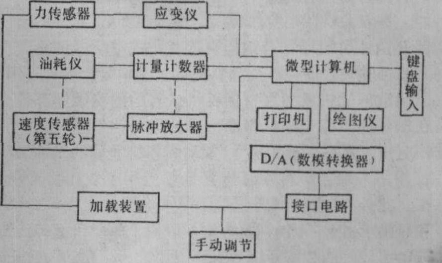
图3 负荷车测试系统框图
供牵引试验用的数据处理装置,有专用数据分析仪和微处理机。最终以曲线和数字打印输出试验结果。监视仪器可显示瞬时值,微处理机还可实现测试的自动控制。
负荷车loadin g car,loading vehicle
一种测定拖拉机牵引力的加载车辆。由仪表车及加载车等组成。两者可制成一体,车的前半部安装测试仪表,后半部为加载的荷重,由拖拉机牵引在田间或试验路面进行牵引试验。负荷车可用以测试拖拉机的牵引特性,也可用来测试轮式拖拉机轮胎的性能及其他试验。