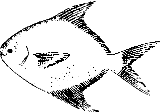
请输入您要查询的百科知识:


词条 Gerald, Missouri
释义

  1. History

  2. Geography

  3. Demographics

     2010 census  2000 census 

  4. References

  5. External links

{{Infobox settlement
|official_name = Gerald, Missouri
|settlement_type = City
|nickname =
|motto =
|image_skyline =
|imagesize =
|image_caption =
|image_flag =
|image_seal =
|image_map = Franklin_County_Missouri_Incorporated_and_Unincorporated_areas_Gerald_Highlighted.svg
|mapsize = 250px
|map_caption = Location of Gerald, Missouri
|image_map1 =
|mapsize1 =
|map_caption1 =
|subdivision_type = Country
|subdivision_name = United States
|subdivision_type1 = State
|subdivision_name1 = Missouri
|subdivision_type2 = County
|subdivision_name2 = Franklin
|government_footnotes =
|government_type =
|leader_title = Mayor
|leader_name = Keith Wehmeyer
|leader_title1 =
|leader_name1 =
|established_title =
|established_date =
|unit_pref = Imperial
|area_footnotes = [1]
|area_magnitude =
|area_total_km2 = 3.86
|area_land_km2 = 3.83
|area_water_km2 = 0.03
|area_total_sq_mi = 1.49
|area_land_sq_mi = 1.48
|area_water_sq_mi = 0.01
|population_as_of = 2010
|population_est = 1312
|pop_est_as_of = 2016
|population_footnotes = [2]
|population_total = 1345
|population_density_km2 = auto
|population_density_sq_mi = auto
|timezone = Central (CST)
|utc_offset = -6
|timezone_DST = CDT
|utc_offset_DST = -5
|elevation_footnotes =
|elevation_m = 275
|elevation_ft = 902
|coordinates = {{coord|38|24|1|N|91|19|53|W|region:US_type:city|display=inline,title}}
|postal_code_type = ZIP code
|postal_code = 63037
|area_code = 573
|blank_name = FIPS code
|blank_info = 29-26866[1]
|blank1_name = GNIS feature ID
|blank1_info = 0755549[2]
|website =
|footnotes =
|pop_est_footnotes = [5]
}}

Gerald is a city in Franklin County, Missouri, United States. The population was 1,345 at the 2010 census.

History

Gerald was platted in 1901 along a railroad line.[3] The community was named after the local Fitzgerald family.[4] A post office called Gerald has been in operation since 1901.[5]

The Christian and Anna Keller Farmstead and Old Gerald School are listed on the National Register of Historic Places.[6][7]

Geography

Gerald is located at {{coord|38|24|1|N|91|19|53|W|type:city}} (38.400397, -91.331279).[8]

According to the United States Census Bureau, the city has a total area of {{convert|1.49|sqmi|sqkm|2}}, of which {{convert|1.48|sqmi|sqkm|2}} is land and {{convert|0.01|sqmi|sqkm|2}} is water.[9]

Demographics

{{US Census population
|1910= 225
|1920= 246
|1930= 344
|1940= 371
|1950= 429
|1960= 474
|1970= 762
|1980= 921
|1990= 888
|2000= 1171
|2010= 1345
|estyear=2016
|estimate=1312
|estref=[10]
|footnote=U.S. Decennial Census[11]
}}

2010 census

As of the census[12] of 2010, there were 1,345 people, 527 households, and 356 families residing in the city. The population density was {{convert|908.8|PD/sqmi|PD/km2|1}}. There were 603 housing units at an average density of {{convert|407.4|/sqmi|/km2|1}}. The racial makeup of the city was 97.5% White, 0.2% African American, 0.8% Native American, 0.5% Asian, 0.1% from other races, and 0.8% from two or more races. Hispanic or Latino of any race were 0.4% of the population.

There were 527 households of which 34.0% had children under the age of 18 living with them, 45.5% were married couples living together, 15.4% had a female householder with no husband present, 6.6% had a male householder with no wife present, and 32.4% were non-families. 26.4% of all households were made up of individuals and 10.6% had someone living alone who was 65 years of age or older. The average household size was 2.50 and the average family size was 2.97.

The median age in the city was 36.6 years. 24.5% of residents were under the age of 18; 9.9% were between the ages of 18 and 24; 26.5% were from 25 to 44; 24.1% were from 45 to 64; and 14.9% were 65 years of age or older. The gender makeup of the city was 48.2% male and 51.8% female.

2000 census

As of the census[1] of 2000, there were 1,171 people, 474 households, and 327 families residing in the city. The population density was 835.0 people per square mile (322.9/km²). There were 510 housing units at an average density of 363.6 per square mile (140.7/km²). The racial makeup of the city was 98.21% White, 0.09% African American, 0.17% Native American, 0.43% Asian, 0.09% from other races, and 1.02% from two or more races. Hispanic or Latino of any race were 0.94% of the population.

There were 474 households out of which 34.0% had children under the age of 18 living with them, 54.4% were married couples living together, 9.1% had a female householder with no husband present, and 31.0% were non-families. 25.7% of all households were made up of individuals and 11.4% had someone living alone who was 65 years of age or older. The average household size was 2.47 and the average family size was 2.97.

In the city the population was spread out with 26.8% under the age of 18, 7.8% from 18 to 24, 29.9% from 25 to 44, 20.5% from 45 to 64, and 15.0% who were 65 years of age or older. The median age was 36 years. For every 100 females, there were 95.2 males. For every 100 females age 18 and over, there were 93.9 males.

The median income for a household in the city was $29,095, and the median income for a family was $35,000. Males had a median income of $28,194 versus $21,971 for females. The per capita income for the city was $14,095. About 6.0% of families and 10.6% of the population were below the poverty line, including 7.9% of those under age 18 and 11.5% of those age 65 or over.

References

1. ^{{cite web |url=http://factfinder2.census.gov |publisher=United States Census Bureau |accessdate=2008-01-31 |title=American FactFinder |deadurl=yes |archiveurl=https://web.archive.org/web/20130911234518/http://factfinder2.census.gov/ |archivedate=2013-09-11 |df= }}
2. ^{{cite web|url=http://geonames.usgs.gov|accessdate=2008-01-31|title=US Board on Geographic Names|publisher=United States Geological Survey|date=2007-10-25}}
3. ^{{cite book | url=https://books.google.com/books?id=xcxWsmxRzVEC&lpg=PP3&pg=PA101#v=onepage&q&f=false | title=Missouri Roadsides: The Traveler's Companion | publisher=University of Missouri Press | author=Earngey, Bill | year=1995 | pages=101}}
4. ^{{cite web|url=http://shsmo.org/manuscripts/ramsay/ramsay_franklin.html |title=Franklin County Place Names, 1928–1945 (archived) |publisher=The State Historical Society of Missouri |accessdate=30 September 2016 |deadurl=bot: unknown |archiveurl=https://web.archive.org/web/20160624071257/http://shsmo.org/manuscripts/ramsay/ramsay_franklin.html |archivedate=24 June 2016 |df= }}
5. ^{{cite web|url=http://www.postalhistory.com/postoffices.asp?task=display&state=MO&county=Franklin |title=Post Offices |publisher=Jim Forte Postal History |accessdate=30 September 2016 |deadurl=yes |archiveurl=https://web.archive.org/web/20141006072247/http://www.postalhistory.com/postoffices.asp?task=display&state=MO&county=Franklin |archivedate=6 October 2014 |df= }}
6. ^{{NRISref|version=2010a}}
7. ^{{cite web|url=http://www.nps.gov/nr/listings/20140703.htm|title=National Register of Historic Places Listings|date=2014-07-03|work=Weekly List of Actions Taken on Properties: 6/16/14 through 6/27/14|publisher=National Park Service}}
8. ^{{cite web|url=https://www.census.gov/geo/www/gazetteer/gazette.html|publisher=United States Census Bureau|accessdate=2011-04-23|date=2011-02-12|title=US Gazetteer files: 2010, 2000, and 1990}}
9. ^{{cite web |title=US Gazetteer files 2010 |url=https://www.census.gov/geo/www/gazetteer/files/Gaz_places_national.txt |publisher=United States Census Bureau |accessdate=2012-07-08 |deadurl=yes |archiveurl=https://www.webcitation.org/64vfLAeJ2?url=http://www.census.gov/geo/www/gazetteer/files/Gaz_places_national.txt |archivedate=2012-01-24 |df= }}
10. ^{{cite web|url=https://www.census.gov/programs-surveys/popest/data/tables.2016.html|title=Population and Housing Unit Estimates|accessdate=June 9, 2017}}
11. ^{{cite web|url=https://www.census.gov/prod/www/decennial.html|title=Census of Population and Housing|publisher=Census.gov|accessdate=June 4, 2015|deadurl=yes|archiveurl=https://www.webcitation.org/6YSasqtfX?url=http://www.census.gov/prod/www/decennial.html|archivedate=May 12, 2015|df=}}
12. ^{{cite web|title=American FactFinder|url=http://factfinder2.census.gov/faces/nav/jsf/pages/index.xhtml|publisher=United States Census Bureau|accessdate=2012-07-08}}

External links

  • Gerald Chamber of Commerce
{{Franklin County, Missouri}}

2 : Cities in Franklin County, Missouri|Cities in Missouri

随便看


开放百科全书收录14589846条英语、德语、日语等多语种百科知识,基本涵盖了大多数领域的百科知识,是一部内容自由、开放的电子版国际百科全书。


Copyright © 2023 OENC.NET All Rights Reserved
京ICP备2021023879号 更新时间:2024/9/22 5:39:54