昆虫区系insect fauna
昆虫类群的地理分布规律。研究昆虫区系可从历史发展状况、生态适应状况和生产实践状况等方面为昆虫地理区划和植物检疫工作提供科学依据。通过调查分析,了解各地昆虫种类组成及分布,明确优势种和特有种,根据历史资料分析所属区系,再结合区域性经济昆虫种类的发生特点,进而制定各地区的昆虫地理区划,或划分植物检疫的疫区和保护区。
昆虫区系的形成,主要取决于地貌变迁、物种的起源及其分布和迁移等因素的综合作用。昆虫的分布与其他动物有共同处,但亦有其特点: ❶昆虫是在大约3.5亿年前的石炭纪进化形成于联合古陆上,由于大陆飘移(见大陆飘移学说),形成了现在地球陆块的分布状况和相应的昆虫区系。各区系既有各自的特有种,也有相互渗透的共同种,故有翅和无翅的原始昆虫遍布于世界各地; 后期进化的有翅昆虫,能跨越许多障碍,分布也很广。
❷昆虫种类众多,每个种有一定的分布范围,在每一分布区内都可找出一些典型种或优势种。
❸昆虫是变温动物,受环境温度变化的影响较大,在寒带分布的种类远少于温暖地。
世界昆虫区系 全世界动物(包括昆虫)按其地理分布状况可分六大区: 古北区(Palaearctic region)、新北区(Nearctic region)、东洋区(Oriental region)、非洲区(Ethiopian region)、新热带区 (Neotropicalregion)和大洋洲区(Australo-papuan region),各区的特点及范围如下(图1)。
古北区 主要是欧亚大陆的温带地区。包括欧洲、非洲北部、小亚细亚、中东、伊朗、阿富汗、苏联、蒙古、中国北部、朝鲜、日本等,以撒哈拉沙漠与非洲区分界,以喜马拉雅山脉至黄河长江之间的地带与东洋区相连。撒哈拉沙漠和喜马拉雅山脉本身的区属尚无定论。全区昆虫种类组成颇为一致,已知有23种蝶类为全区所共有;舞毒蛾发生在不列颠和整个欧洲,并断续地东伸到中国、日本,每个孤立的群体都构成一个不同的亚种。
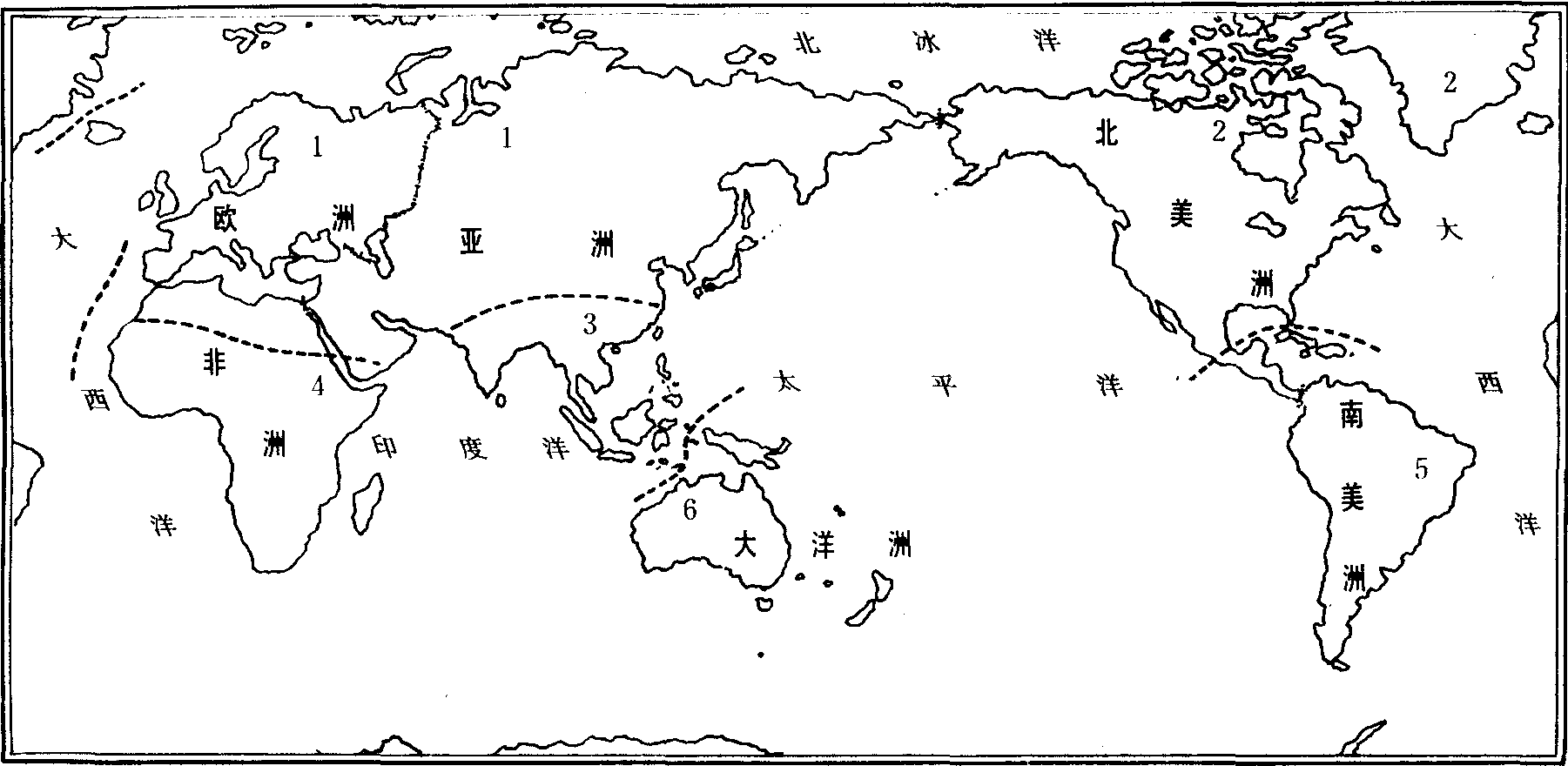
1. 古北区; 2. 新北区; 3. 东洋区; 4. 非洲区; 5. 新热带区; 6. 大洋洲区
新北区 包括北美大陆,北自阿拉斯加,南达墨西哥的北回归线,还包括东北方的一些岛屿如格陵兰,但不包括夏威夷。在气候上,这一区与古北区相似,昆虫种类组成也有若干相似之处,有时合称全北区。周期蝉是北美昆虫中最特出的一个类群,共有6种,其中3种需13年才能成熟,另3种则需17年,但由于种群个体差异,表现地区或年度间成虫出现期参差不齐,有的地区几乎每年出现。本区Gryllus属的蟋蟀发现7种,与古北区的普通大田蟋有亲缘关系,形态也极近似,但能根据不同的生物学特性区别,有些种类以成虫,有些则以卵态越冬,二者地理分布也不相同。新北区和古北区的蛾蝶类同样有较密切的亲缘关系,但相同的种类不多。
东洋区 位于热带,亚热带地区,包括中国中、南部、热带亚洲、斯里兰卡,菲律宾以及某些毗邻的小岛,东达帝汶的西里伯斯和小巽他群岛,南与大洋洲区隔海相邻。喜马拉雅山脉及其东、西部延伸部分,在古北区和东洋区之间形成一条天然分界线。大桕蛾是本地区代表种,体形大,翅展近33厘米; 大蜜蜂也是这地区的典型种,无固定蜂巢,如环境不利,即弃旧巢而他迁。苏门答腊、婆罗洲、爪哇等南洋诸岛与大陆间虽被海洋所隔,但还处同一大陆架上,故属同一昆虫区系。
非洲区 包括撒哈拉沙漠以南的非洲,三面环海,撒哈拉沙漠形成一条到古北区的过渡地带。有的学者把马达加斯加岛单分为古岛区系。非洲区与东洋区昆虫的亲缘关系最密切,其中有许多属,甚至某些种为共有的,然亦各有特点。采采蝇可作为本区的代表种,能传播睡眠病,颇影响热带非洲文化的发展。本区的白蚁种类和数量十分丰富,在非洲的自然生态和人类经济中起着重要的作用。非洲西部的特有种巨金龟,可能是世界上最重和最粗壮的昆虫。在非洲的纳米比亚沙漠,发现不少稀奇古怪的甲虫,其中伪步甲就达200种以上,多数在世界其他地方尚未发现; 蝶类中的斑蝶科绝大多数已知种都为非洲区所特有。
新热带区 北起墨西哥的北回归线,包括中美和南美,以及西印度群岛,南至玻利维亚、巴拉圭和巴西南部。昆虫类群丰富多样,且高度特化。本区蝶类具有奇异的色彩和花纹,蔚为奇观,如大翅蝶科、透翅蝶科、长翅蝶科,是这个区的特有类群,几乎整个科的种类均局限在本区。新热带雨林中的蚂蚁种类十分丰富,切叶蚁几乎只生活在本区,可将灌木树叶切成小片,然后携带回巢。还有行军蚁,为捕猎性,无固定巢穴,四处游猎。
大洋洲区 主要由大洋洲大陆,塔斯马尼亚及巴布亚新几内亚所组成。大洋洲区除南极外在中生代就被海洋与大陆的其余部分隔开。因此大洋洲区还存在着许多古老的动物类型,以及某些值得注意的活化石昆虫,如达尔文乳白蚁的某些生物学特性,还保持其近亲螳螂的祖征。古蜓科是一类原始昆虫,世界上仅知9种,其中4种产于大洋洲,一种叫 Petalura in-gentissima,可算是世界上最大的蜻蜓。蝙蝠蛾是现存最原始的蛾类之一,全世界已知约200种,本区就有近100种,也是大洋洲区的孑遗昆虫。
中国昆虫区系 中国昆虫区系是世界陆地昆虫区系的一个组成部分,分属于古北区和东洋区。两区在中国境内的分界线,西部以喜马拉雅山系及秦岭为界;东部因地势平坦,缺乏限制迁移的大屏障,南方种可向北延伸到45°N或更北,北方种可向南延伸到南岭北缘或更南。其间形成一条混合带,故对这一部分的分界线,诸家说法不一。
根据中国科学院《中国自然地理》编辑委员会(1979)对中国动物地理区划的意见,古北区在中国部分可再分为东北、华北、蒙新、青藏四区; 东洋区再分为西南、华中、华南三区(图2)。
东北区 包括41°N以北的大小兴安岭,张广才岭、老爷岭,长白山以及松花江和辽河平原的广大农、林区。气候寒温湿润。山地昆虫多为能耐高寒而以森林为生境的种类,如落叶松毛虫、落叶松鞘蛾、山楂粉蝶等。平原害虫主要属中国-喜马拉雅种类,东部与日本北海道情况相近似,北部则有许多西伯利亚成分,西南部有部分中亚细亚成分侵入。主要种类如大豆食心虫、苜蓿夜蛾、草地螟、粟叶甲、东北大黑金龟甲等。本区南部亦有少数东洋区系的广布种伸入,如稻纵卷叶螟、白背飞虱、亮绿丽金龟等。
华北区 北界东起燕山山区、张北台地、吕梁山、六盘山北部、向西止于祁连山脉东端,南抵秦岭、淮河,东临渤海,包括黄土高原、冀热山地及黄淮平原,属暖温带,冬寒夏热。本区为中国历史最悠久的农业区,分布较普遍和为害较重的农业害虫代表种有: 华北蝼蛄、东亚飞蝗、苜蓿盲蝽、沟叩头虫、黑绒金龟甲、苹小食心虫、东方粘虫、麦红吸浆虫、粟灰螟等。本区有较多东洋区种类侵入,愈近南缘,比重渐大,如苏北、皖北等地,可占1/3左右。
蒙新区 包括内蒙古高原、河西走廊、塔里木、准噶尔盆地和天山山地,在大兴安岭以西,大青山以北,由呼伦贝尔草原直到新疆西陲。东、北、西三面与苏联及蒙古人民共和国毗邻,南界则为青藏高原。气候属半干燥及干燥型,东西部差异较显著,西部多少还可受到西来湿润气候的影响,形成草原及荒漠型。在农业害虫组成上,本区东部的内蒙古、河西一带,与华北区北缘的种类较相近;牧草地上蝗虫种类甚多,亦为本区东部地带的特色,其中雏蝗属、雏膝蝗属、痂蝗属及束颈蝗属,均有一些优势种。西部的新疆则以中亚种类占优势。苹果蠹蛾、谷粘虫、普通蝼蛄、苜蓿籽小蜂、新疆实蝽、麦穗金龟甲为本区特有种。
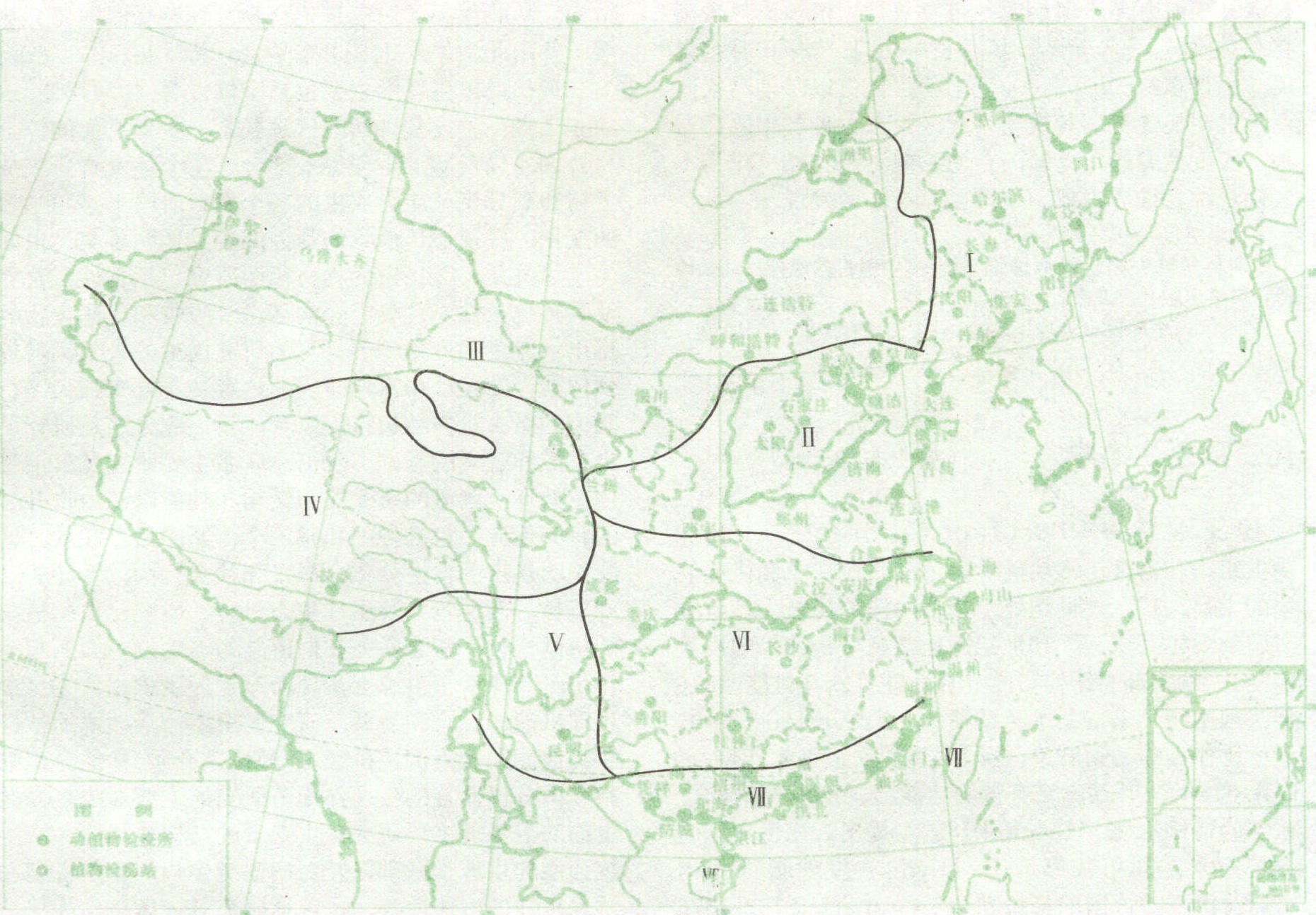
图2 中国昆虫区系
Ⅰ.东北区;Ⅱ.华北区;Ⅲ.蒙新区;Ⅳ.青藏区;Ⅴ.西南区;Ⅵ.华中区;Ⅶ.华南区
青藏区 北缘在帕米尔高原向东伸延至祁连山一线,南界喜马拉雅山,东及东南则以四川西部、云贵高原西北部高山、康滇峡谷森林草地相接,包括柴达木盆地、青藏高原、昆仑山地及藏南山地。本区高原与谷地的气候相差悬殊,高原年平均气温在0℃以下,冬季漫长寒冷,年雨量100毫米左右。谷地年平均气温达9~10℃,年雨量在100毫米以上,高达400~500毫米。大多数昆虫属中国喜马拉雅种类,亦有较多中亚细亚成分及地区特有种。蝗虫种类已知50多种,西藏牧草蝗、柴达木束颈蝗等,为本区特有种。金龟中亦有不少接近东方特有种,如藏斑金龟、藏花金龟等;草原毛虫的为害很突出。
西南区 包括四川西部、昌都东部,北起青海、甘肃南缘,南抵云南中北部(大致以26°N为南界),向西直达藏东喜马拉雅山脉南坡的针叶林带以下山地,基本上是南北平行走向的高山与峡谷。气候较复杂,冬春晴朗多风,干湿季明显,月平均气温在6~22℃间,年雨量1 000~1 500毫米。昆虫组成十分丰富,半数以上是东洋区系的印度马来亚种类,亦有一定数量为古北区系的中国喜马拉雅种类,还有少数中亚成员及地区特有种。长江以南主要农林害虫如三化螟、稻苞虫、稻黑尾叶蝉、褐飞虱、红铃虫、鼎点金刚钻、荔蝽等,在本区均可找到,还有中亚的大菜粉蝶、小翅雏蝗等,亦可在本区发现。
华中区 包括四川盆地及长江流域各省。西部北起秦岭,东半部为长江中、下游,包括东南沿海丘陵的北部,南部与华南区相邻,即大致为南亚热带的北界。气候属亚热带暖湿类型,年降雨量为1 000~1 750毫米间,是中国主要稻、茶产区。农业害虫种类多数与华南区和西南区相同,中国喜马拉雅种类和印度马来亚种类在数量上各占一定比例。而以后者稍占优势,极少西伯利亚成分,绝无中亚细亚成分。三化螟、二化螟、稻纵卷叶螟、褐稻虱、黑尾叶蝉、棉红铃虫、金刚钻、棉铃虫等,均是本区重要的稻、棉大害虫。
华南区 包括两广和云南的南部,福建东南沿海,台湾及南海各岛,属南亚热带及热带,植被为热带雨林和季雨林、全年无冬,夏季长6~9月,7~10月多台风,雨量在1500~2000毫米间。昆虫以印度马来西亚种占明显优势,其次为古北区系东方种类中的广布种,印度黄脊蝗、荔蝽、台湾稻螟、圆花蝽可作为本区代表种。堆砂白蚁,中国也只在本区发现。