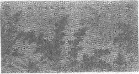
词条 | Freeport, Bahamas |
释义 |
|official_name = City of Freeport |other_name = |settlement_type = |image_skyline = Lucayan Harbor JonWorth.jpg |imagesize = 260px |image_caption = |image_flag = |flag_size = |image_seal = |seal_size = |image_shield = |shield_size = |nicknames =The Industrial Capital The Second City |motto = |image_map = |mapsize = |map_caption = |image_map1 = |mapsize1 = |map_caption1 = |pushpin_map = Bahamas |pushpin_label_position = |pushpin_mapsize = |pushpin_map_caption = |coordinates = {{coord|26|31|43|N|78|41|48|W|region:BS|display=inline,title}} |subdivision_type = Country |subdivision_name = {{flag|The Bahamas}} |subdivision_type1 = Island |subdivision_type2 = District |subdivision_type3 = |subdivision_type4 = |subdivision_name1 = Grand Bahama |subdivision_name2 = City of Freeport |subdivision_name3 = |subdivision_name4 = |established_title = Established |established_date = 1955 |established_title2 = |established_date2 = |established_title3 = |established_date3 = |government_footnotes = |government_type = District Council |leader_title = Chief Councillor |leader_name = Kendal Culmer |leader_title1 = |leader_name1 = |unit_pref = |area_footnotes = |area_magnitude = |area_total_km2 = 558 |area_total_sq_mi = 215 |area_land_km2 = |area_land_sq_mi = |area_water_km2 = |area_water_sq_mi = |area_water_percent = |area_urban_km2 = |area_urban_sq_mi = |area_metro_km2 = |area_metro_sq_mi = |area_blank1_title = |area_blank1_km2 = |area_blank1_sq_mi = |elevation_footnotes = |elevation_m = 10|elevation_ft =|population_total = 26,914|population_as_of = 2000|population_footnotes =|population_density_km2 = 48|population_density_sq_mi = 125|population_urban =|population_density_urban_km2 =|population_density_urban_sq_mi =|population_metro = 55,500|population_density_metro_km2 =|population_density_metro_sq_mi =|population_blank1_title =|population_blank1 =|population_density_blank1_km2 =|population_density_blank1_sq_mi =|population_note =|postal_code_type =|postal_code =|area_code = 242|website = http://gbpa.com/home/|city_logo =|citylogo_size =|image_dot_map =|dot_mapsize =|dot_map_caption =|dot_x = |dot_y =|governing body = City of Freeport District Council|leader_title2 = Deputy Chief Councillor|leader_name2 = Ernie Barr |leader_title3 =|leader_name3 =|leader_title4 =|leader_name4 =|timezone = Eastern Time Zone|utc_offset = -5|timezone_DST =|utc_offset_DST =|blank_name =IATA airport code|blank_info =FPO|blank1_name = ICAO airport code|blank1_info =MYGF}}Freeport is a city, district and free trade zone on the island of Grand Bahama of the northwest Bahamas. In 1955, Wallace Groves, a Virginian financier with lumber interests in Grand Bahama, was granted {{convert|50000|acres|0|abbr=on}} of pineyard with substantial areas of swamp and scrubland by the Bahamian government with a mandate to economically develop the area. Freeport has grown to become the second most populous city in the Bahamas.The main airport serving the city is the Grand Bahama International Airport, which receives domestic flights from various islands of the Bahamas as well as several international flights from the United States and Canada. Freeport is also served by domestic Bahamian ferry services to other islands.The Grand Bahama Port Authority (GBPA) operates the free trade zone, under the Hawksbill Creek Agreement signed in August 1955 whereby the Bahamian government agreed that businesses in the Freeport area would pay no taxes before 1980, later extended to 2054.{{cite web|last=Blount|first=Steve|title=Freeport, Bahamas|url=https://www.usatoday.com/story/experience/cruise/destinations/bahamas/2013/07/01/freeport-bahamas-port-guide/2455245/|publisher=USA Today|accessdate=8 January 2014}} 2. ^{{cite web| first=| last=| title=Freeport Grand Bahama | work=Government of the Bahamas| date= | url=http://www.britannica.com/EBchecked/topic/640195/West-Indies}} 3. ^{{cite web|title=The History of Freeport, Grand Bahama Island|url=http://the-bahamas.net/the-islands/freeport-bahamas/|accessdate=8 January 2014}} 4. ^{{cite web|title=The National Parks of The Bahamas|url=http://www.bnt.bs/The-National-Parks-of-The-Bahamas/Lucayan-National-Park|publisher=Bnt.bs|accessdate=8 January 2014}} 5. ^^ Walker, N. D., Roberts, H. H., Rouse, L. J. and Huh, O. K. (1981, November 5). Thermal History of Reef-Associated Environments During A Record Cold-Air Outbreak Event. Coral Reefs (1982) 1:83–87 6. ^{{cite web|url =http://worldweather.wmo.int/en/city.html?cityId=1633 |title =Climatological Information|publisher=WMO|year=2016}}Retrieved on November 24, 2011. Further reading
External links{{Sister project links|wikt=no|v=no|n=no|q=no|s=no|b=no|voy=Freeport (Bahamas)}}
6 : Districts of the Bahamas|Populated places in the Bahamas|Grand Bahama|Populated places established in 1955|1955 establishments in the British Empire|Freeport, Bahamas |
随便看 |
|
开放百科全书收录14589846条英语、德语、日语等多语种百科知识,基本涵盖了大多数领域的百科知识,是一部内容自由、开放的电子版国际百科全书。