饲料酵母fodder yeast
林产化学工业中以木材水解液、木材酸法制浆废液及其酒精发酵后的酒槽等为原料,通过发酵而得的蛋白饲料产品。此外,还可以其他含糖介质及碳氢化合物或醇类生产。
酵母菌是一种肉眼看不见的单细胞微生物。它有两大类: 一类为有性繁殖,能形成子囊孢子,属子囊菌纲; 另一类未发现有性繁殖,不能产生子囊孢子,属半知菌纲。两类酵母菌有许多共同性,如菌体单细胞,球形、卵圆形、椭圆形或长方形,一般都能以芽殖方式进行无性繁殖,少数裂殖,大都能形成假菌丝。按用途不同,酵母菌分为食用酵母和饲料酵母。前者的生产原料以己糖为主,后者除己糖外还可利用戊糖和部分有机酸、低分子醇类。林产化学工业生产的酵母,主要是饲料酵母。
简史 早在19世纪30年代人们发现酿酒精发酵液的沉淀中有活的微生物,其细胞呈圆形至卵圆形,大多是单一的。这种微生物具有酿酒精发酵作用,发酵时最初发泡,以后又沉淀,人们就以酒精发酵现象来命名,如荷兰称为“发泡”; 德国叫“沉渣”; 中国叫“酵母”,指发酵之母。“酵母” 一词本指引起酒精发酵的微生物,后来发现与其相似的菌类很多,有的并没有酿酒精发酵的作用,但由于形态和真酵母相似,也都归入酵母菌类。
20世纪50年代以来,饲料酵母工业在世界上发展很快,特别是苏联和一些东欧国家十分重视利用森林工业产生的剩余物和废液以及其他资源发展饲料酵母工业。苏联在80年代初期,饲料酵母年产量已达120万吨,其中有半数以上以林、农副产品为原料。每吨绝干森林工业废料可生产干酵母量: 对木屑水解糖液酒糟戊糖为24~40千克; 对木材加工企业废料戊糖为70~85千克, 己糖100~120千克,戊糖和己糖185~250千克; 对采伐废料戊糖为95~100千克,己糖75~90千克,戊糖和己糖170~175千克。中国在50年代开始以森林工业废渣废液为原料制取饲料酵母。在60年代初建成了中国第一个酵母生产酒精和饲料酵母的水解厂。到80年代仍处于起步阶段。
成分 饲料酵母含有大量蛋白质,如以亚硫酸盐浆废液为原料生产的产朊假丝酵母,菌体主要化学成分为: 水分9%,蛋白质45~48%,脂肪0.9%,灰分8%。饲料酵母含有50%左右的粗蛋白质(含有动物生长所必需的氨基酸)和维生素。其重要的氨基酸和维生素含量均优于一般的饲料和谷物。
生产方法 饲料酵母生产的关键技术是: 选择适宜的菌种,创造适宜的繁殖环境,以及分离干燥工作。
菌种用无孢子酵母,并选对-五碳糖、有机酸利用率高,生活力强,且能耐高温的菌株。各国用的菌种多为产朊假丝酵母(Candida utilis)(图1)。该菌的特
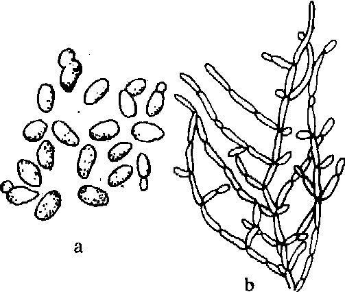
图1 产朊假丝酵母
a.芽孢子; b.假菌丝
饲料酵母的加工过程:❶营养液制备,包括去除有害的物质,调整pH值、温度,添加营养盐等;
❷酵母增殖,保持适当的酸碱度和温度,但更重要的是在增殖过程中供给酵母必要的空气(供氧),以利酵母生长所需能量和构成细胞物质;
❸酵母的分离和洗涤;
❹酵母干燥和包装。酵母增殖率高低与发酵罐的性能关系极大。世界上已有多种产率高、能耗低的发酵罐。根据生产经验,糖浓度较低的废液宜采用气提式或喷雾轮式发酵罐。发酵宜采用半连续式工艺(如分割法、流加法等)。用木材水解液或亚硫酸盐浆废液为原料生产饲料酵母,可采用连续化生产的方式。亚硫酸盐浆废液生产饲料酵母工艺见图2。
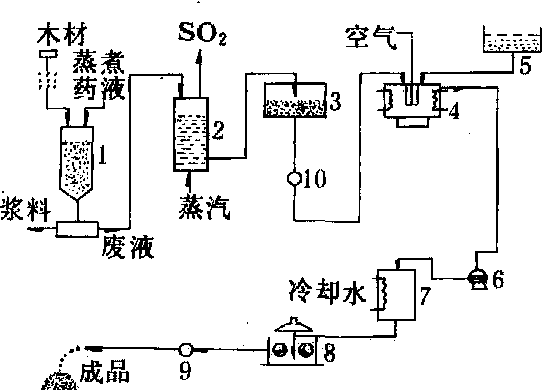
图2 亚硫酸制浆废液生产饲料酵母流程
1.蒸煮锅;2.曝气塔;3.中和槽;4.发酵槽;5.营养盐槽;6.酵母分离机;7.酵母乳液贮槽;8.辊筒干燥
器;9.粉碎机;10.冷却器
产品规格和用途 外观为颗粒或粉末状,淡黄至褐色。含水率≤9%,蛋白质35~45%,灰分≤10%。饲料酵母含蛋白质和维生素较高,广泛用作牲畜和家禽饲料或饲料添加剂。饲养效果好,经济收益明显。如用1千克酵母饲养家禽,可增加肉2.2~2.9千克,增产鸡蛋30个左右;喂猪可增长0.7~0.8千克肉;饲喂奶牛可增加6升奶或增加1.1千克左右的牛肉;饲养狐狸等毛皮兽,可代替2千克肉类,且能改进毛皮质量。饲料酵母还可用以提取核糖核酸、辅酶A、卵磷脂和凝血质等重要成分。核糖核酸通过降解,可制取2',3'混合核苷酸及其他核苷酸衍生物。这些产物是优良的植物生长激素,也是重要的药物或生化试剂。
饲料酵母
见单细胞蛋白。
饲料酵母fodder yeast
供作饲料用的酵母。以工农业副产品和废弃产物如废糖蜜、酒糟、纸浆废液和枯物粗纤维等为原料,接种一定量的热带假丝酵母(Candida tropicalis)或食用球拟酵母(Torulopsis ufilis),又称产肮假丝酵(Candidautilis),在适当的温度、湿度和通氧条件进行发酵,生产饲料酵母。
- (八) 农村财政政策
- (八)农村运输
- (八) 农民收人
- (八)农民收入、消费水平逐步提高
- (八)农民收入大幅度增加,生活水平显著提高
- (八)农民生活
- (八)农民生活改善
- (八)农民生活普遍改善
- (八) 农民生活水平不断提高
- (八)农用工业基础设施建设
- (八) 冰雹
- (八)冰雹
- (八) 创立了适合社会主义市场经济的经营机制,为国有企业转换机制提供了有益的经验
- (八) 初级社的管理
- (八)利废再生型
- (八)加强农业发展支撑体系建设
- (八)加强渍涝、盐碱化改良理论研究和治理规划
- (八) 加强领导,密切配合
- (八)包群到户的“铁畜制”
- (八)化隆县甘都园艺场
- (八) 北京市养猪育种中心
- (八) 北京市林木种子苗木管理总站
- (八)北海市南珠市场
- (八)医药管理
- (八)南城淮山