叮咚
分类:【地域文化】
叮咚,黎族民间古老的单人敲击乐器。相传古时候,黎族人民为了保护农作物,用两根木棒互相敲击,发出叮叮咚咚的声响,以驱逐禽兽,并以此取乐。后来,经过不断的加工和改良,发展成为黎族人民喜爱的能伴歌伴舞的乐器。“叮咚”琴取料于一种质硬而轻的 “中苹树”原木,选用两根各长5尺,直径约3寸的木杆,一根为“叮”音,另一根为“咚”音,将木料去皮后,用藤条把杆的两端悬吊平行,“叮”杆在上,“咚”杆在下,相距5寸。敲击时有低、中、高音,一般为6、1、2、3、5的音阶。音调主要通过移动吊挂两根木棒的绳索进行调节,击打的位置不同,声音也不同,长而粗的木杆,发声为低音; 短而小的木杆,发声为高音。“叮咚曲”乐声清晰,节奏轻快,高昂悦耳,且变化多样,黎家五个支系,都异曲同工。
黎族古老的民间打击乐器。亦称“打叮咚”、“咚咚”。流行于海南省黎族地区。它用几种特殊的木料制成。音调清脆、铿锵。制作方法较简单:先选好木料并去皮做横木;用绳索或红绸布将横木悬吊在大树枝或人工搭成的木架两端。用两节小硬木(约1尺长)做敲棍。横木多少不一,两根、三根,甚至四、五根均可。唯乐东、东方和昌江县一带是用一根木料劈成两半,一半厚而宽,一半薄而窄。横木的大小、长短没有一定标准;大者直径4寸,小者直径2.5寸;长者丈许,短者1.5尺或五尺均可。用两根木料制成的,一般只能发出纯4度的音阶,上根为1~5,下根为6~3。音调通过移动吊挂两根木棒的红绸布或绳索进行调节;敲击多用两拍和四拍,三拍甚少,节奏多为对称手法。演奏时,通常用左手反复敲打同一音调作为衬托音,用右手以先慢后快的节奏敲击主旋律,运用变奏法形成高潮。敲击得越有节奏就越动听。用三根以上的木料制成的“叮咚”,可得7个音阶,其敲击技巧复杂、节奏多变。
 曝杂记
曝杂记 丝
丝 鷃
鷃 叔山父𣪕
叔山父𣪕 姒簠
姒簠 貉
貉 咎如
咎如 轩学派
轩学派 鼎
鼎 分裆鼎
分裆鼎 簋
簋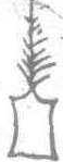 尊
尊 甗
甗
 尊
尊 谐记
谐记 哙
哙 军
军
 之役
之役 麾
麾
 拜
拜 筒木弩
筒木弩 球
球