台湾稻螟Taiwan rice stem borer
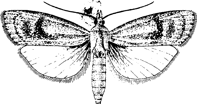
水稻等作物的蛀茎害虫。学名Chilotraea auricilia(Dudgeon)。鳞翅目,螟蛾科。分布于缅甸、泰国、尼泊尔、越南、柬埔寨、印度、印度尼西亚、斯里兰卡、巴基斯坦、菲律宾。中国南方稻区亦有分布。为害水稻及甘蔗、玉米、高粱、粟等作物。雄蛾体长6.5~8.5毫米,翅展18~23毫米,触角略呈锯齿状。前翅黄褐色,散布暗褐色点,中央有隆起的具金属光泽的深褐色斑块4个,外缘有7个小黑点;后翅淡黄褐,白缘毛。雌体长9.2~11.8毫米,翅展23~28毫米,触角丝状,前翅黄褐色,斑纹较雄蛾粗大,色淡,后翅与雄蛾相似(见图)。卵扁椭圆形,初产时白色,后变灰黄色,卵粒鱼鳞状排列,通常1~3行,偶或多至5行。幼虫5~7龄,末龄体长16~25毫米,头暗红色至黑褐色,胸腹部呈不鲜明的白色,间或呈淡黄色或略带淡褐色。背面有5条紫褐色纵线。蛹长9~16毫米,纺锤形,初蛹黄色,后渐变黄褐到深褐色,背面有5条褐色纵纹。
台湾稻螟
中国南方稻区年生3~6代,多以幼虫在稻桩中越冬。广东越冬代发蛾期与二化螟蛾基本一致,以后各代则比二化螟蛾早发。成虫有趋光性,喜在浓绿的稻苗上产卵,每只雌蛾可产卵4~6块,每块有卵30粒左右,多者达190粒。初孵幼虫,吐丝飘散,多从叶鞘、叶耳处侵入,不易发现侵入孔。侵入后,先集中在叶鞘内取食,形成枯鞘;也有蛀茎,造成枯心苗和白穗。幼虫常转株为害,蛀孔大而呈方形,虫粪多排出孔外。幼虫老熟后爬到最外层叶鞘内,选择适当位置吐丝结薄茧化蛹;已侵入稻茎的幼虫,则迁移到稻株近水面6~10厘米处,将稻茎内壁咬一环状羽化孔,只留薄膜,然后在茎内化蛹。羽化后破膜而出。此虫在蔗稻混栽区,对甘蔗也有一定危害。防治二化螟可兼治此虫。
台湾稻螟Taiwan rice stem borer
Chilo auriciliusDudgeon,昆虫纲,鳞翅目,螟蛾科。分布于广东、广西、福建、湖南、江西、台湾、云南等省区;南亚、东南亚也有分布。寄主有水稻、玉米、甘蔗等。成虫翅展20~26 mm,黄至黄褐色,前翅散生暗褐色鳞片,外缘色泽较暗,中央有深褐色斑点4个,其中3个排成斜列,外缘有7个小黑点,缘毛金黄色,有光泽,后翅缘毛略呈银白色。末龄幼虫体长16~25 mm,头壳暗红至黑褐色,体呈暗白带淡黄褐色,背面有紫红色纵纹5条。广东、广西一年发生4~5代,以幼虫在稻秆或稻桩内越冬。成虫有趋光性,喜在粗秆、宽叶浓绿的稻株上产卵,卵块鱼鳞状,产于叶片上。幼虫孵化后从叶鞘处咬孔钻入,有群集性,常转株为害,受害茎穿孔多,内壁组织损伤重,稻株易折断,为害状同二化螟。末龄幼虫多在茎秆内、间有在叶鞘上、卷叶内或分蘖间化蛹。可采取在冬春消灭越冬虫源,低龄幼虫期喷洒农药等防治措施。