吉州窑玳瑁釉碗
宋代吉州窑瓷器。传世品。口径十四点五厘米,造型特点是侈口,圆唇,腹壁削直,底足小,圈足矮,胎体薄,规整,很像南方农民头上戴的斗笠。外壁施黑釉,内壁也施黑釉,黑釉不太黑。在施黑釉的同时在一些部位又施淡黄釉,这些淡黄釉块深浅各不相同,安排很随意,有的成块状,有的成条状,经窑火焙烧,釉层在高温中液化,各种颜色的釉层流动,相互浸润,烧成以后淡黄色釉部分像飞溅的水花,也像飘动的彩云,更像生活在大海中的动物玳瑁的骨骼。这完全是一种艺术上高超的构思和巧作,没有用什么昂贵稀有的原料,也没有什么高难的工艺流程,全凭工匠们具有的娴熟的艺术技巧和奇特的艺术构思。吉州窑玳瑁釉瓷器的创作和生产,在我国工艺发展史上给人们很多有益的启示。现藏于北京故宫博物馆。
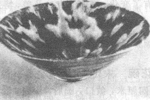
吉州窑玳瑁釉碗