朱砂叶螨carmine spider mite
多食性重要害螨。又名红叶螨、棉红蜘蛛。学名Tetranychuscinnabarinus (Boisduval)。蛛形纲,蜱螨目,叶螨科。1971年从复合种T. telarius Linnaeus中分出。分布世界各温暖地区。中国北至河北、山西、西至甘肃、四川、南至广东、广西、云南、东濒沿海、台湾均有分布。寄主植物有棉花、黄麻、苎麻、烟草、玉米、豆类、芝麻、茄、辣椒、瓜类、木槿、月季、向日葵、桑、柳、楝、槐、光风轮菜、小旋花、马鞭草、五爪金龙等100余种。
形态特征 雌螨体长0.48~0.55毫米,宽0.32毫米。体形椭圆,体色常随寄主而异,其基本色调为锈红或深红色,颚体黄色。躯体两侧有黑斑2对,须肢端感器长约为宽的2倍; 背感器梭形,与端感器约等长。口针鞘前端圆钝,中央无凹陷,气门沟末端呈U形弯曲,内腰毛和内骶片间形成菱状肤纹,肤纹突三角形至半圆形。雄螨体长0.35毫米,宽0.19毫米,头胸部前端近圆形,腹部末端稍尖,体色比雌虫淡。第一对足跗节有两对双刚毛,彼此远离,各足爪间突裂成3对针状刺,爪变成两对粘毛,位于爪间突的两侧。须肢端感器长约为宽的3倍;背感器比端感器稍短。阳具弯向背面,形成端锤,其近侧突起尖利或稍圆,远侧突起尖利,长度约等。端锤背缘形成一钝角,形状和大小个体间常有差异。卵圆球形,直径约0.13毫米,初产时无色透明,渐变淡黄,孵化前微红。幼螨足3对,蜕皮后变为第一若螨,再蜕皮为第二若螨,足4对,第二若螨蜕皮后为成螨。
与朱砂叶螨近似的种有二点叶螨(或称棉叶螨),分布于江西、上海、陕西、云南、四川、山东、广西、广东、甘肃、山西、新疆等地。寄主植物有棉花、玉米、高粱、花生、烟草、洋麻、苹果、向日葵、七叶树、榆、圆叶牵牛、美人蕉、梅、益母草、醉鱼草、茑萝、胭脂花、狗尾草、旱金莲、构树、刺桐、三七等。与朱砂叶螨的主要区别是雄螨体色淡黄或黄绿色,越冬滞育的雌螨橙红色,后半体肤纹突呈较宽阔的半圆形,卵初产时白色,雌螨有滞育。其他近似种尚有截形叶螨,分布于河北、河南等省棉田: 神泽叶螨,分布于江苏、浙江等省棉田。体色均为深红色,主要区别为雄性外生殖器形态不同。
生活习性 中国北方棉区年生12~15代,南方棉区年生18~20代,华南棉区20代以上。北方棉区10月中、下旬雌螨吐丝结网,以橙红色滞育型聚集在向阳枯枝落叶、杂草根际、树皮隙缝或土块缝中越冬。南方棉区雌螨除在上述场所外,还以成、若螨和卵态在杂草、绿肥、蚕豆株上继续繁殖。春季雌螨出蛰活动,10℃以上开始产卵,主要在蚕豆、小麦、苜蓿、苕子及紫花地丁、光风轮菜、阿拉伯婆婆纳、车前草、牛尾草等寄主植物上繁殖,2~3代后5月份向棉苗上转移,形成点片发生。随着气温上升,为害不断扩大,6~8月是为害盛期。8月中旬以后转移到秋寄主如野苋菜、五爪金龙、小旋花、茄及桑、杨、柳、榆等。10月气温下降,棉株衰老,再转移到秋播作物和杂草上准备越冬。为害棉花时,常聚集在叶背用口针刺入叶片取食栅栏层细胞的叶绿粒和细胞液,影响光合作用,致叶片变红干枯脱落。
繁殖方式以两性生殖为主,也可营产雄孤雌生殖。雌螨一生多交配一次,少数可多次交配。第二若螨的静止期能散发法尼醇类(farnesol)雌性信息素吸引雄性在其周围等待。最后一次蜕皮刚变成螨时即行交配,雄螨可多次交配,交配后1~3天产卵,多散产在棉叶背面,每雌日平均产卵6~8粒,一生可产卵113~165粒。雌雄性比约为5:1,产卵期一个月左右。雄螨寿命短,一般交配后即死亡。
朱砂叶螨通常先在田边和有寄主杂草的地方点片发生,以受害株为中心向周围扩散。通过爬行或凭借风力、流水、昆虫、鸟兽和农业机具的传带传播。当棉叶受害严重、营养条件恶化时,常吐丝下垂,借风和流水扩散。低洼棉田受渍涝后,叶螨常暴发成灾。水平扩散速度受中心虫源数量多少、气温、湿度、降雨量及强度、风向、风速和地势而变化。在棉株上的分布随棉花生育期而变化,苗期和蕾期主要在中、下部,花铃期在中、上部。
发生规律 西北内陆棉区于7月下旬至9月下旬发生一次高峰,黄河流域棉区于6月中下旬至8月中旬发生两次高峰,长江流域棉区于4月下旬至9月上旬发生3~5次高峰。第一次高峰期常出现在5月中下旬,如遇春旱亦可提早在5月初;第二次高峰在6月中旬至7月初夏熟作物收获后;第三次在7月中下旬,此时温度高,繁殖快,如遇干旱即能猖獗成灾;第四次在8月上中旬之间,如伏旱接秋旱,而前期又防治不力,则常可导致红叶落叶、成灾失收;第五次在9月上旬、从棉田大量转移到其他寄主植物上过冬。
在夏秋多雨的年份,为害状况常因雨量增大而受抑制。南方棉区棉田间、套作物种类多,冬春又未经翻耕、枯枝落叶和杂草较多,能积累大量虫源,有利于繁殖为害。
朱砂叶螨发育起点温度为7.7~8.8℃,40℃以上对叶螨的寿命和繁殖有抑制作用。发育上限温度为42℃,最适温度25~30℃,卵的历期在日平均气温14.8℃时为9天,21.0℃时6.1天,25.4℃时3.2天,28℃时2.8天。幼螨若螨期在日平均气温20.5℃时为10.2天,22.6℃时为7天,25.0℃时为5.1天,30.0℃时为4天。26~30℃繁殖最快,完成一代只需7~8天,23~25℃为10~13天,20℃以下完成一代需17天以上。在棉花生长季节,高温干旱,最有利于叶螨的活动和繁殖。降雨强度愈大,对叶螨的冲刷力愈强。6~8月月降雨量在100毫米以下时为大发生年,在100~200毫米为中等发生年,200毫米以上为轻发生年,在此期间如果有连续10~15天的短期干旱,则这个月仍有大发生的可能。
防治方法 采取农业防治和化学防治相结合的综合措施:❶重点消灭虫源,及时控制点片发生。一熟棉田结合冬耕或冬灌消灭虫源,两熟套种棉田结合田间管理,铲除杂草虫源。玉米和棉花套种棉田,适时摘除玉米中、下部老叶,防止叶螨向棉株上转移。棉苗出土后,及时铲除棉田和田边杂草。
❷药剂防治。60年代初期朱砂叶螨又分别对三硫磷,敌敌畏、甲拌磷等有机磷杀虫剂产生不同程度的交互抗性。应用选择性农药有独特的防治效果,而对天敌杀伤作用小,有利于维护棉田生态。有机农药如久效磷、甲胺磷、乐果等与杀螨剂(如三氯杀螨醇、克螨特、双甲脒等)混合或交替使用,可起到提高药效、延缓抗性和兼治多种害虫的作用。采用氧乐果或久效磷涂茎的办法也有良好的防治效果,且对天敌影响小。
❸利用天敌。常见天敌有拟长毛钝绥螨、食卵赤螨、塔六点蓟马、横纹蓟马、深点食螨瓢、小花蝽、七星瓢虫、龟纹瓢虫、异色瓢虫、十三星瓢虫、三色长蝽、大草蛉、中华草蛉、丽草蛉、草间小黑珠、三突花蛛等30余种。其中捕食量大的有塔六点蓟马,日捕食成若螨和卵10头以上。拟长毛钝缓螨专食性强,繁殖快,与叶螨数量为1:50时,10天内可控制为害。
朱砂叶螨carmine spider mite
Tetranychus cinnabarinus(Boisduval),又称红叶螨,棉红蜘蛛。蜱螨亚纲,真螨目,叶螨科。分布在世界温暖地区,中国广泛分布。寄主植物有棉花、黄麻、苎麻、烟草、玉米、豆类、芝麻、茄子、辣椒、瓜类、桑、柳、槐等100余种。本种与二斑叶螨十分相似,主要区别是:足Ⅰ胫节刚毛数有变异,分别为10、12、13根。阳茎近侧突钝圆,远侧突尖锐,端锤背部隆起点居其外侧1/3,为钝角,但阳茎形状也有变异。幼、若螨Ⅰ体色为黄绿色,体背两侧具褐斑,发育至若螨Ⅱ时,体色逐渐呈橘红色,至成螨则为锈红或深红色,体背仍具褐斑。体背菱状肤纹的纹突较狭而尖。体内苹果酸酶同工酶和苹果酸脱氢酶同工酶与二斑叶螨显著不同。以化学防治(如内吸性有机磷拌种)为主;或苗期勤查挑治,也可选种抗螨品种。
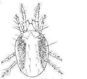
雌螨背面观
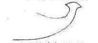
阳茎侧面观
朱砂叶螨