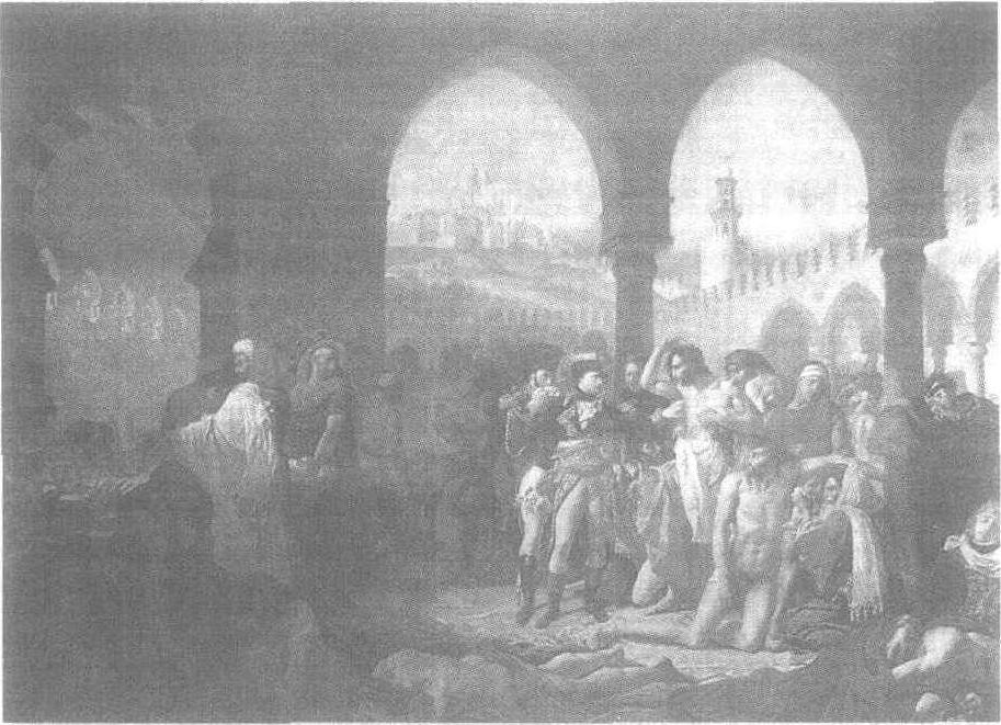
请输入您要查询的百科知识:


词条 Cook County, Minnesota
释义

  1. History

  2. Geography

     Major highways  Adjacent counties  Protected areas[5] 

  3. Climate

  4. Demographics

  5. 2000 census

  6. Communities

     City  Census-designated place  Unincorporated communities[5]  Townships  Unorganized territories  Ghost towns 

  7. Politics

  8. See also

  9. References

  10. External links

Not to be confused with Cook, Minnesota in Saint Louis County.{{Infobox U.S. county
| county = Cook County
| state = Minnesota
| seal =
| founded = 9 March 1874
| seat wl = Grand Marais
| largest city = Grand Marais
| area_total_sq_mi = 3340
| area_land_sq_mi = 1452
| area_water_sq_mi = 1887
| area percentage = 57%
| census estimate yr = 2017
| pop = 5,398
| density_sq_mi = 3.72
| time zone = Central
| web = www.co.cook.mn.us
| named for = Michael Cook
| ex image = Cook County Courthouse.jpg
| ex image cap = Cook County Courthouse
| district = 8th
}}

Cook County is a county in the U.S. state of Minnesota. Around 1.8 million visitors travel to Cook County each year.//www.visitcookcounty.com/in-the-news/grand-marais-minn-named-one-of-the-16-best-places-to-live-in-the-u-s-2016-by-outside-magazine/ As of the 2010 United States Census, the population was 5,176,[1] making it the fifth-least populous county in Minnesota. Its county seat is Grand Marais.[2] The Grand Portage Indian Reservation is entirely within the county.

History

The first inhabitants of this area were the Ojibwe people. The first non-indigenous people to see the area were French fur traders, a few of whom settled in the area (by the 1830s the French population of this area was a few dozen). In the 1830s, settlers began arriving from New England and from upstate New York. Completion of the Erie Canal (1825) and settling of the Black Hawk War (1831) made this migration wave safer and easier.

Most of Cook County's 1830s settlers came from Orange County, Vermont and Down East Maine (modern day Washington County and Hancock County). Most were fishermen and farmers. By 1845 the future Cook County contained some 350 people of European descent; by 1874 there were about two thousand. They were primarily members of the Congregational Church, Methodist, and Baptist churches. By 1900 there were about 3,000 people in Cook County.

The first decade of the twentieth century saw a large influx of Europeans, from Germany, Scandinavia, and Ireland. These waves introduced Lutheranism and Catholicism to Cook County.

The county was created on 9 March 1874.[3] It was named for Michael Cook, Territorial and State Senator[4]

Geography

Cook County is a rugged, heavily wooded triangle of land on the NE tip of Minnesota. It abuts the southern border of Canada, the western border of the state of Wisconsin, and is largely surrounded by the northern end of the Great Lakes. It is heavily dotted with lakes, ponds and streams.[5] The state's highest point is in the county, at 2,301' (701m) ASL. The county has a total area of {{convert|3340|sqmi}}, of which {{convert|1452|sqmi}} is land and {{convert|1887|sqmi}} (57%) is water.[6] It is the second-largest county in Minnesota by total area. The highest natural point in Minnesota, Eagle Mountain at {{convert|2301|ft}}, and the highest lake in Minnesota, Lake Abita at {{convert|2048|ft}}, are located in Cook County. Lake Superior is at the county's southern border.There is only one traffic light in the county.

Major highways

  • Minnesota State Highway 61
  • Cook County Road 12 – Gunflint Trail

Adjacent counties

Cook County is in the extreme northeast of the state at the tip of the Arrowhead region; it is adjacent to only one other county by land. Its geographic neighbors are:

  • Rainy River District, Ontario Canada - northwest
  • Thunder Bay District, Ontario Canada - northeast (EST Border east of the 90th meridian west)
  • Lake County - west
  • Ashland County, Wisconsin - south
  • Keweenaw County, Michigan - east/EST Border
  • Ontonagon County, Michigan - southeast/EST Border

Protected areas[5]

{{div col}}
  • Cascade River State Park
  • Grand Portage National Monument
  • Judge CR Magney State Park
  • Kodunce River State Wayside Area
  • North Shore State Trail (part)
  • Pat Bayle State Forest
  • Superior National Forest (part)
    • Boundary Waters Canoe Area Wilderness (part)
  • Temperance River State Park
{{div col end}}

Climate

{{Weather box
|location = Lutsen, Minnesota
|single line= Y
|Jan high F = 22
|Feb high F = 26
|Mar high F = 35
|Apr high F = 47
|May high F = 56
|Jun high F = 64
|Jul high F = 70
|Aug high F = 70
|Sep high F = 62
|Oct high F = 52
|Nov high F = 39
|Dec high F = 27
|year high F=
|Jan low F = 4
|Feb low F = 7
|Mar low F = 19
|Apr low F = 31
|May low F = 39
|Jun low F = 45
|Jul low F = 52
|Aug low F = 54
|Sep low F = 47
|Oct low F = 38
|Nov low F = 26
|Dec low F = 11
|year low F=
|Jan rain inch = 0.9
|Feb rain inch = 0.7
|Mar rain inch = 1.4
|Apr rain inch = 1.9
|May rain inch = 2.8
|Jun rain inch = 3.5
|Jul rain inch = 3.3
|Aug rain inch = 3.3
|Sep rain inch = 3.6
|Oct rain inch = 2.5
|Nov rain inch = 1.6
|Dec rain inch = 1.1
|year rain inch=26.4
|Jan snow inch = 15.2
|Feb snow inch = 8.1
|Mar snow inch = 8.1
|Apr snow inch = 2.2
|May snow inch = 0.2
|Jun snow inch = 0
|Jul snow inch = 0
|Aug snow inch = 0
|Sep snow inch = 0
|Oct snow inch = 0.4
|Nov snow inch = 3.8
|Dec snow inch = 13.3
|year snow inch= 50.8
|source 1 = Weatherbase[7]
|date=August 2010
}}

Northern Minnesota offers extreme winter weather. While the averages are low, the extremes provide more details. A third of the year is below freezing (31.9%, 116 days, or 4 months). Of those days, 21 are below zero degrees Fahrenheit (−17.8 °C).

Jan Feb Mar Apr May June Jul Aug Sep Oct Nov Dec Year
Days Below 32 °F/0 °C[7]
20 18 19 13 3.5 0.1 0.1 0.0 0.5 5.8 16 20 116
Days Below 0 °F/-17.8 °C[7]
8.2 6 1.5 0 0 0 0 0 0 5 0.5 4.8 21

Demographics

{{US Census population
|1880= 65
|1890= 98
|1900= 810
|1910= 1336
|1920= 1841
|1930= 2435
|1940= 3030
|1950= 2900
|1960= 3377
|1970= 3423
|1980= 4092
|1990= 3868
|2000= 5168
|2010= 5176
|estyear=2017
|estimate=5398
|estref=[8]
|align-fn=center
|footnote=US Decennial Census[9]
1790-1960[10] 1900-1990[11]
1990-2000[12] 2010-2016[1]
}}{{Stack|}}

2000 census

As of the 2000 United States Census,[13] there were 5,168 people, 2,350 households, and 1,438 families in the county. The population density was 3.56/sqmi (1.37/km²). There were 4,708 housing units at an average density of 3.24/sqmi (1.25/km²). The racial makeup of the county was 89.45% White, 7.59% Native American, 0.33% Asian, 0.29% Black or African American, 0.04% Pacific Islander, 0.25% from other races, and 2.05% from two or more races. 0.75% of the population were Hispanic or Latino of any race. 21.6% were of German, 17.7% Norwegian, 11.5% Swedish, 7.2% Irish and 5.4% English ancestry.

There were 2,350 households out of which 24.40% had children under the age of 18 living with them, 52.00% were married couples living together, 6.10% had a female householder with no husband present, and 38.80% were non-families. 32.50% of all households were made up of individuals and 10.80% had someone living alone who was 65 years of age or older. The average household size was 2.17 and the average family size was 2.73.

The county population contained 20.40% under the age of 18, 5.40% from 18 to 24, 25.80% from 25 to 44, 31.20% from 45 to 64, and 17.20% who were 65 years of age or older. The median age was 44 years. For every 100 females there were 99.70 males. For every 100 females age 18 and over, there were 98.50 males.

The median income for a household in the county was $36,640, and the median income for a family was $47,132. Males had a median income of $31,211 versus $23,650 for females. The per capita income for the county was $21,775. About 8.10% of families and 10.10% of the population were below the poverty line, including 12.20% of those under age 18 and 6.80% of those age 65 or over.

Communities

City

  • Grand Marais (county seat)

Census-designated place

  • Lutsen

Unincorporated communities[5]

{{div col}}
  • Croftville
  • Grand Portage
  • Hovland
  • Maple Hill
  • Martin Landing
  • Mineral Center
  • Pigeon River
  • Sawbill Landing
  • Schroeder
  • Taconite Harbor
  • Tofte
{{div col end}}

Townships

  • Lutsen Township
  • Schroeder Township
  • Tofte Township

Unorganized territories

  • East Cook
  • Grand Portage
  • West Cook

Ghost towns

  • Chippewa City
  • Colvill

Politics

Cook County voters have generally voted Democratic. In 78% of national elections since 1980 (as of 2016), the county selected the Democratic Party candidate.

{{Hidden begin|titlestyle=background:#ccccff|title=Presidential election results}}
Presidential elections results[14]
Year Republican Democratic Third parties
34.1% 1,1569.6% 327
36.8% 1,2213.3% 108
37.0% 1,2402.7% 89
45.1% 1,4892.5% 81
45.9% 1,29512.6% 354
39.9% 1,01013.8% 350
33.5% 87828.1% 735
49.4% 1,0781.2% 26
51.6% 1,2190.6% 13
50.6% 1,14710.9% 248
48.5% 1,0343.7% 78
57.6% 1,0471.5% 28
49.3% 8535.7% 99
43.9% 7640.1% 2
60.2% 9870.2% 4
61.7% 1,0780.1% 2
65.1% 9460.3% 5
47.9% 6743.1% 44
48.1% 5130.8% 8
49.3% 6730.5% 7
32.1% 3872.0% 24
43.3% 4185.8% 56
72.6% 6091.3% 11
68.0% 47127.9% 193
72.9% 46711.9% 76
34.4% 12520.9% 76
8.6% 3072.7% 253
78.0% 2559.2% 30
82.8% 2074.8% 12
52.6% 815.2% 8
42.2% 812.1% 4
51.5% 6834.1% 45
{{Hidden end}}

See also

  • National Register of Historic Places listings in Cook County, Minnesota

References

1. ^{{cite web|title=State & County QuickFacts|url=http://quickfacts.census.gov/qfd/states/27/27031.html|publisher=United States Census Bureau|accessdate=August 31, 2013}}
2. ^{{cite web|url=http://www.naco.org/Counties/Pages/FindACounty.aspx|accessdate=7 June 2011|title=Find a County|publisher=National Association of Counties|deadurl=yes|archiveurl=https://web.archive.org/web/20110531210815/http://www.naco.org/Counties/Pages/FindACounty.aspx|archivedate=31 May 2011}}
3. ^{{cite web|title=Minnesota Place Names|url=http://mnplaces.mnhs.org/upham/county.cfm|publisher=Minnesota Historical Society|accessdate=March 17, 2014}}
4. ^{{cite book|last=Upham|first=Warren|title=Minnesota Geographic Names: Their Origin and Historic Significance|url=https://books.google.com/books?id=ShcLAAAAYAAJ&pg=PA135|year=1920|publisher=Minnesota Historical Society|page=135}}
5. ^[https://www.google.com/maps/place/Cook+County,+MN/@47.8954886,-90.2651883,14z/data=!4m5!3m4!1s0x52a7eb3e40eeab69:0x1a1bd253b0ba433!8m2!3d47.6051056!4d-90.4931767 Cook County MN Google Maps (accessed 6 March 2019)]
6. ^{{cite web|url=https://www.census.gov/geo/maps-data/data/docs/gazetteer/counties_list_27.txt|publisher=US Census Bureau|accessdate=October 6, 2014|date=August 22, 2012|title=2010 Census Gazetteer Files|deadurl=yes|archiveurl=https://web.archive.org/web/20131019110737/http://www.census.gov/geo/maps-data/data/docs/gazetteer/counties_list_27.txt|archivedate=October 19, 2013}}
7. ^{{cite web|url=http://www.weatherbase.com/weather/weather.php3?s=282312&refer=|title=Weatherbase: Historical Weather for Lutsen MN|accessdate=January 9, 2009}}
8. ^{{cite web|url=https://www.census.gov/programs-surveys/popest/data/tables.2017.html|title=Population and Housing Unit Estimates|accessdate=6 March 2019}}
9. ^{{cite web|url=https://www.census.gov/prod/www/decennial.html|title=US Decennial Census|publisher=US Census Bureau|accessdate=October 6, 2014|deadurl=yes|archiveurl=https://www.webcitation.org/6YSasqtfX?url=http://www.census.gov/prod/www/decennial.html|archivedate=May 12, 2015}}
10. ^{{cite web|url=http://mapserver.lib.virginia.edu|title=Historical Census Browser|publisher=University of Virginia Library|accessdate=October 6, 2014}}
11. ^{{cite web|url=https://www.census.gov/population/cencounts/mn190090.txt|title=Population of Counties by Decennial Census: 1900 to 1990|publisher=US Census Bureau|accessdate=October 6, 2014}}
12. ^{{cite web|url=https://www.census.gov/population/www/cen2000/briefs/phc-t4/tables/tab02.pdf|title=Census 2000 PHC-T-4. Ranking Tables for Counties: 1990 and 2000|publisher=US Census Bureau|accessdate=October 6, 2014}}
13. ^{{cite web|url=http://factfinder2.census.gov|publisher=US Census Bureau|accessdate=31 January 2008|title=American FactFinder|deadurl=yes|archiveurl=https://web.archive.org/web/20130911234518/http://factfinder2.census.gov/|archivedate=11 September 2013}}
14. ^{{Cite web|url=http://uselectionatlas.org/RESULTS|title=Atlas of US Presidential Elections|last=Leip|first=David|website=uselectionatlas.org|access-date=17 April 2018}}

External links

  • Cook County Government's website
  • Mn/DOT – maps of Cook County ([https://web.archive.org/web/20120908012450/http://www.dot.state.mn.us/maps/cadd/county/cook1.pdf Southwest portion], [https://web.archive.org/web/20120910161640/http://www.dot.state.mn.us/maps/cadd/county/cook2.pdf Eastern portion], [https://web.archive.org/web/20120910161713/http://www.dot.state.mn.us/maps/cadd/county/cook3.pdf Northwest portion])
{{Geographic location
|Centre = Cook County, Minnesota
|North = Thunder Bay District, Ontario {{flagicon|CAN}}
|Northeast = Thunder Bay District, Ontario {{flagicon|CAN}}
|East = Lake Superior
Keweenaw County, Michigan
|Southeast = Lake Superior
Ontonagon County, Michigan
|South = Lake Superior
Ashland County, Wisconsin
|Southwest = Lake Superior
Bayfield County, Wisconsin
|West = Lake County
|Northwest = Rainy River District, Ontario {{flagicon|CAN}}
}}{{Cook County, Minnesota}}{{Minnesota}}{{Coord|47|55|N|90|33|W|region:US-MN_type:adm2nd_source:dewiki|display=title}}

4 : Minnesota counties|Cook County, Minnesota|1874 establishments in Minnesota|Populated places established in 1874

随便看


开放百科全书收录14589846条英语、德语、日语等多语种百科知识,基本涵盖了大多数领域的百科知识,是一部内容自由、开放的电子版国际百科全书。


Copyright © 2023 OENC.NET All Rights Reserved
京ICP备2021023879号 更新时间:2024/9/20 11:45:33